Category:Wavertree Garden Suburb Institute
Jump to navigation
Jump to search
| Object location | | View all coordinates using: OpenStreetMap |
|---|
architectural structure in Liverpool, Merseyside, England, UK  | |||||
| Upload media | |||||
| Instance of | |||||
|---|---|---|---|---|---|
| Location | Liverpool, Merseyside, North West England, England | ||||
| Heritage designation |
| ||||
 | |||||
Two early 19th century houses, converted into the Institute in 1912 and Grade II listed.
Media in category "Wavertree Garden Suburb Institute"
The following 6 files are in this category, out of 6 total.
-
 Benchmark at Wavertree Garden Suburb Institute.jpg 4,192 × 3,164; 11.49 MB
-
 Wavertree Garden Suburb Institute (1).JPG 4,000 × 3,000; 2.89 MB
-
 Wavertree Garden Suburb Institute 1.jpg 5,152 × 3,864; 7.69 MB
-
 Wavertree Garden Suburb Institute 2.jpg 5,152 × 3,864; 6.71 MB
-
 Wavertree Garden Suburb Institute 2017.jpg 4,908 × 3,296; 10.11 MB
-
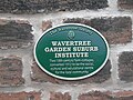 Wavertree Garden Suburb Institute plaque.jpg 5,152 × 3,864; 7.62 MB
.JPG)


