Category:Waterpoort (Zaltbommel)
Jump to navigation
Jump to search
| Object location | | View all coordinates using: OpenStreetMap |
|---|
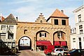
city gate of Zaltbommel, Netherlands  | |||||
| Upload media | |||||
| Instance of | |||||
|---|---|---|---|---|---|
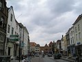
| Location | Zaltbommel, Gelderland, Netherlands | ||||
| Street address |
| ||||
| Located on street | |||||
| Heritage designation |
| ||||
 | |||||
Nederlands: Waterpoort Zaltbommel
|
This is a category about rijksmonument number 40285
|
| Address |
|
Media in category "Waterpoort (Zaltbommel)"
The following 13 files are in this category, out of 13 total.
-
 2010-8 waterpoort 4 def; Waterstraat 46, nr. 40280.jpg 3,972 × 2,648; 1.48 MB
-
 40285 waterpoort.jpg 3,000 × 2,237; 5.1 MB
-

-
 Overzicht - Zaltbommel - 20101344 - RCE.jpg 1,200 × 894; 152 KB
-
 Overzicht Waterstraat - Zaltbommel - 20219607 - RCE.jpg 1,183 × 1,200; 273 KB
-
 Poort met Waterstraat naar het noorden - Zaltbommel - 20219626 - RCE.jpg 1,200 × 884; 182 KB
-
 Poort stadszijde - Zaltbommel - 20219628 - RCE.jpg 1,200 × 944; 227 KB
-
 Poort, reproductie van prentbriefkaart - Zaltbommel - 20219624 - RCE.jpg 919 × 1,200; 272 KB
-
 Poort, stadszijde na de restauratie - Zaltbommel - 20219625 - RCE.jpg 1,200 × 950; 210 KB
-

-
 Stadspoort Waterstraat Zaltbommel Nederland.JPG 2,592 × 1,944; 2.14 MB
-
 Waterpoortzaltbommel.jpg 1,193 × 803; 188 KB
-
 Zaltbommel waterpoort.jpg 2,048 × 1,536; 1.53 MB


