Category:Watermill in Sidra
Jump to navigation
Jump to search
| Object location | | View all coordinates using: OpenStreetMap |
|---|
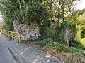
- Polski: Młyn wodny W Sidrze, 1890 r.
 | |||||
| Upload media | |||||
| Instance of | |||||
|---|---|---|---|---|---|
| Location | Sidra, Gmina Sidra, Sokółka County, Podlaskie Voivodeship, Poland | ||||
| Heritage designation |
| ||||
| Inception |
| ||||
 | |||||
Media in category "Watermill in Sidra"
The following 10 files are in this category, out of 10 total.
-
 Sidra mlyn 01.jpg 4,000 × 3,000; 8.92 MB
-
 Sidra mlyn 02.jpg 4,000 × 3,000; 7.2 MB
-
 Sidra mlyn 03.jpg 6,000 × 8,000; 21.76 MB
-
 Sidra mlyn 04.jpg 6,000 × 8,000; 23.77 MB
-
 Sidra mlyn 05.jpg 8,000 × 6,000; 21.8 MB
-
 Sidra mlyn 06.jpg 8,000 × 6,000; 24.06 MB
-
 Sidra mlyn 07.jpg 8,000 × 6,000; 25.72 MB
-
 Sidra mlyn 08.jpg 8,000 × 6,000; 23.44 MB
-
 Sidra mlyn 09.jpg 8,000 × 6,000; 23.79 MB
-
 Sidra mlyn 10.jpg 8,000 × 6,000; 23.02 MB


