Category:Watermill in Goworów
Jump to navigation
Jump to search
| Object location | | View all coordinates using: OpenStreetMap |
|---|
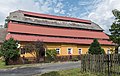
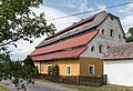
Polski: Goworów 65 - młyn wodny, 1 ćw. XX
Media in category "Watermill in Goworów"
The following 4 files are in this category, out of 4 total.
-
 2017 Młyn wodny w Goworowie 1.jpg 4,251 × 2,702; 7.63 MB
-
 2017 Młyn wodny w Goworowie 2.jpg 4,508 × 3,146; 8.87 MB
-
 2017 Młyn wodny w Goworowie 3.jpg 4,586 × 3,151; 9.29 MB
-
 2017 Młyn wodny w Goworowie 4.jpg 4,736 × 3,189; 8.07 MB


