Category:Water towers of Villejuif
Jump to navigation
Jump to search
Arrondissement of Créteil:
Arrondissement of l'Haÿ-les-Roses: Villejuif ·
Arrondissement of Nogent-sur-Marne:
Arrondissement of l'Haÿ-les-Roses: Villejuif ·
Arrondissement of Nogent-sur-Marne:
| Object location | | View all coordinates using: OpenStreetMap |
|---|
 | |||||
| Upload media | |||||
| Instance of | |||||
|---|---|---|---|---|---|
| Location | Villejuif, Val-de-Marne, Île-de-France, Metropolitan France, France | ||||
| Located on street | |||||
| Heritage designation | |||||
| Inception |
| ||||
 | |||||
Media in category "Water towers of Villejuif"
The following 4 files are in this category, out of 4 total.
-
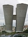 Villejuif - Chateaux d'eau - vue rapprochée.jpg 2,448 × 3,264; 387 KB
-
 Villejuif - Chateaux d'eau.jpg 3,264 × 2,448; 454 KB
-
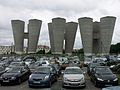
 Villejuif - parking de l'IGR - fokuso.jpg 2,280 × 1,276; 865 KB
-
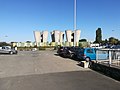 Villejuif - parking de l'IGR.jpg 3,968 × 2,976; 2.26 MB


