Category:Water availability maps of the world
Jump to navigation
Jump to search
Maps about availability, access and/or scarcity of (potable) water.
Media in category "Water availability maps of the world"
The following 16 files are in this category, out of 16 total.
-
 2006 Global Water Availability.svg 863 × 443; 1.63 MB
-
 Annual-exhaustion-of-water-supplies.jpg 701 × 389; 126 KB
-
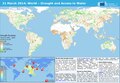 ECDM 20140321 World Drought WaterAccess.pdf 1,625 × 1,125; 531 KB
-
 ECDM 20240322 World Water Day.pdf 2,479 × 1,754; 982 KB
-
 Map Water scarcity.PNG 1,028 × 424; 343 KB
-
 Proportion-of-population-with-basic-handwashing-facilities-on-premises.jpg 3,400 × 2,400; 384 KB
-
 Safe drink tap water map.png 1,357 × 628; 32 KB
-
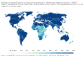 Share of population using at least basic drinking water source, OWID.svg 850 × 600; 141 KB
-

-

-
 Share of urban population with improved water sources, OWID.svg 850 × 600; 142 KB
-
 Water stress 2019 WRI.png 1,425 × 625; 54 KB
-
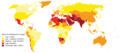
 Water Stress Around 2000 A.D. By WaterGAP.jpg 1,540 × 800; 134 KB
-
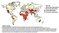 Waterschaarste.UNESCO2012.jpg 1,115 × 642; 175 KB
-
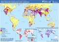
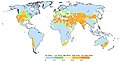
 WWDR4 Global physical and economic water scarcity.png 800 × 404; 57 KB
-
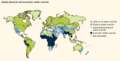
 WWDR4 Water scarcity.PNG 1,028 × 424; 360 KB


