
Category:Wasserturm Oranienburg
| Object location | | View all coordinates using: OpenStreetMap |
|---|
This is the category of the Brandenburger Baudenkmal (cultural heritage monument) with the ID 09165358 (Wikidata)
|
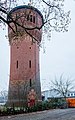
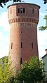
water tower in Oranienburg, Germany  | |||||
| Upload media | |||||
| Instance of | |||||
|---|---|---|---|---|---|
| Location | Oranienburg, Oberhavel District, Brandenburg, Germany | ||||
| Heritage designation | |||||
 | |||||
Media in category "Wasserturm Oranienburg"
The following 5 files are in this category, out of 5 total.
-
 Oranienburg Wasserturm 1.jpg 2,736 × 3,648; 2.49 MB
-
 Oranienburg Wasserturm-01.jpg 4,000 × 5,333; 8.05 MB
-
 Oranienburg Wasserturm-02.jpg 4,000 × 6,000; 8.96 MB
-
 Oranienburg Wasserturm-03.jpg 3,670 × 5,871; 6.45 MB
-
 Oranienburg Wasserturm.jpg 1,723 × 3,062; 3.07 MB


