Category:Wasserturm (Klostermansfeld)
Jump to navigation
Jump to search
| Object location | | View all coordinates using: OpenStreetMap |
|---|
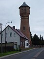
water tower in Klostermansfeld, Germany  | |||||
| Upload media | |||||
| Instance of | |||||
|---|---|---|---|---|---|
| Location | Klostermansfeld, Mansfelder Grund-Helbra, Mansfeld-Südharz, Saxony-Anhalt, Germany | ||||
| Heritage designation | |||||
| Start time |
| ||||
 | |||||
This is the category of the Saxony-Anhalt Kulturdenkmal (cultural heritage monument) with the ID 09475581 (Wikidata)
|
Media in category "Wasserturm (Klostermansfeld)"
The following 6 files are in this category, out of 6 total.
-
 Helbra, Blick zur Siedlung Benndorf und zum Wasserturm Klostermansfeld.JPG 4,272 × 2,848; 3.34 MB
-
 KLG 4481 Klostermansfeld, Wasserturm, Neue Str.jpg 6,016 × 3,384; 8.97 MB
-
 Klostermansfeld Wasserturm 1.jpg 1,500 × 2,000; 762 KB
-
 Klostermansfeld Wasserturm 2.jpg 1,650 × 2,200; 853 KB
-
 Klostermansfeld, the southern part of the Neue Straße und the water tower.jpg 2,551 × 1,701; 706 KB
-
 Klostermansfeld, view to the village.jpg 2,638 × 1,584; 878 KB


