Category:Washington State Route 504
Jump to navigation
Jump to search
State highway in southwestern Washington, US  | |||||
| Upload media | |||||
| Instance of | |||||
|---|---|---|---|---|---|
| Location | Washington, Pacific Northwest, Washington, Pacific States Region | ||||
| Transport network | |||||
| Owned by | |||||
| Maintained by | |||||
| Inception |
| ||||
| Length |
| ||||
| |||||
| « First · 500 · 501 · 502 · 503 · 504 · 505 · 506 · 507 · 508 · 509 · 510 · 512 · 513 · 514 · Last » |
| I-5 · I-82 · I-90 · I-182 · I-205 · I-405 · I-605 · I-705 |
| US-2 · US-10 · US-12 · US-95 · US-97 · US-99 · US-101 · US-195 · US-197 · US-295 · US-395 · US-730 · US-830 |
English: This category should contain files related to Washington State Route 504.
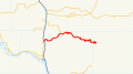
Washington State Route 504 aka Spirit Lake Highway.
Subcategories
This category has the following 9 subcategories, out of 9 total.
Media in category "Washington State Route 504"
The following 29 files are in this category, out of 29 total.
-
 2023 South Coldwater Slide 02.jpg 4,608 × 2,592; 3.28 MB
-
 500px photo (204708327).jpeg 2,048 × 1,365; 668 KB
-
 WA-504.svg 600 × 600; 7 KB
-
 Cars on st helens1.jpg 1,023 × 407; 75 KB
-
 Eastern terminus of Spirit Lake Highway after May 18th eruption (36074323001).jpg 5,328 × 3,600; 17.31 MB
-
 Kid Valley bridge on SR 504, July 1980.jpg 3,483 × 2,329; 6.74 MB
-
 Lahar field 3393.jpg 4,608 × 3,072; 3.7 MB
-
 Logging trucks 8901.jpg 6,000 × 4,000; 10.48 MB
-
 Logging trucks 8902.jpg 6,000 × 4,000; 6.99 MB
-
 Mount St. Helens mudflow deposit on State Highway 504 near Toutle, 1980.jpg 5,640 × 3,924; 11.31 MB
-
 MP 26 8888.jpg 6,000 × 4,000; 11.57 MB
-
 MP 41 9087.jpg 6,000 × 4,000; 10.46 MB
-
 MP 41 9089.jpg 6,000 × 4,000; 10.33 MB
-
 Mudflow covering SR 504 near Coal Bank bridge, July 1980.jpg 3,483 × 2,329; 9.98 MB
-
 NToutle Plain 8887.jpg 6,000 × 4,000; 7.53 MB
-
 NToutle Plain panorama 8883.jpg 9,855 × 3,729; 9.03 MB
-
 NToutle Plain panorama 8884.jpg 11,984 × 3,805; 14.59 MB
-
 Old Highway 504, Toutle River Valley (1811015935).jpg 1,600 × 1,200; 698 KB
-
 Sasquach.jpg 2,592 × 1,456; 1.35 MB
-
 SR 504 - Coal Bank bridge after lahar.jpg 3,483 × 2,329; 6.13 MB
-
 State Route 504 eastbound approaching Mount St. Helens near Castle Lake.jpg 4,908 × 3,258; 6.24 MB
-
 Toutle River Bridge after 1980 Mount St. Helens eruption.jpg 5,622 × 3,975; 11.33 MB
-
 Toutle valley 3403.jpg 4,608 × 3,072; 2.92 MB
-
 Volcano 3394.jpg 4,608 × 3,072; 3.5 MB
-
 WA 504 3398.jpg 4,608 × 3,072; 2.76 MB
-
 WA 504 3399.jpg 4,608 × 3,072; 3.94 MB
-
 WA-504 St. Helens Bridge after 1980 eruption.jpg 5,643 × 3,714; 9.92 MB
-
 WA-504 St. Helens Bridge prior to eruption.jpg 5,517 × 3,714; 9.68 MB
-
 Washington State Route 504.svg 1,152 × 640; 163 KB

.jpeg)

.jpg)


.jpg)


