Category:Wasenbrunnen (Laufenburg AG)
Jump to navigation
Jump to search
| Object location | | View all coordinates using: OpenStreetMap |
|---|
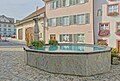
fountain in Laufenburg in the canton of Aargau, Switzerland  | |||||
| Upload media | |||||
| Instance of | |||||
|---|---|---|---|---|---|
| Part of | |||||
| Location | Laufenburg, Laufenburg District, Aargau, Switzerland | ||||
| Street address |
| ||||
| Heritage designation | |||||
 | |||||
Media in category "Wasenbrunnen (Laufenburg AG)"
The following 4 files are in this category, out of 4 total.
-
 Altstadt Laufenburg (AG) - Wasenbrunnen.jpg 4,200 × 2,800; 7.1 MB
-
 Laufenburg AG - Wasenbrunnen & Hinterer Wasen.jpg 4,000 × 3,000; 7.43 MB
-
 Laufenburg AG - Wasenbrunnen & Obere Wasengasse.jpg 4,000 × 3,000; 9.44 MB
-
 Laufenburg AG Wasenbrunnen.jpg 5,391 × 3,627; 8.31 MB
_-_Wasenbrunnen.jpg)

