Category:Warter
Jump to navigation
Jump to search
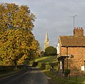
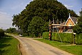
English: Warter is a village and civil parish in the East Riding of Yorkshire, England. It is situated approximately 4 miles (6.4 km) east of Pocklington on the B1246 road.
village in the United Kingdom .jpg) | |||||
| Upload media | |||||
| Instance of | |||||
|---|---|---|---|---|---|
| Location | East Riding of Yorkshire, Yorkshire and the Humber, England | ||||
| Population |
| ||||
 | |||||
Subcategories
This category has the following 19 subcategories, out of 19 total.
B
- Bailey Dale, Warter (3 F)
- Blanch Dale Plantation (4 F)
- Brig Dale (11 F)
G
- Great Dug Dale (34 F)
H
- Hedges in Warter (279 F)
K
- Keasey Dale (3 F)
L
- Lavender Dale (10 F)
- Lings Plantation, Warter (4 F)
N
- Nettle Dale (14 F)
R
- Ringlands Plantation (6 F)
S
- Sylvan Dale (19 F)
T
- Thorn Dale, Warter (4 F)
- Townend Wood (9 F)
V
- Village pond, Warter (11 F)
W
- Warter War Memorial (9 F)
- Well Dale (9 F)
Media in category "Warter"
The following 200 files are in this category, out of 650 total.
(previous page) (next page)-
 A boarded up Coldwold Farmhouse - geograph.org.uk - 2138047.jpg 800 × 600; 196 KB
-
 A bridleway to the north of Water - geograph.org.uk - 2644118.jpg 800 × 600; 201 KB
-
 A choice of paths - geograph.org.uk - 3629784.jpg 1,024 × 768; 174 KB
-
 A house in Milldale - geograph.org.uk - 1215571.jpg 640 × 405; 361 KB
-

-
 A kissing gate south of Water - geograph.org.uk - 2644111.jpg 800 × 600; 311 KB
-
 A minor road at Loaningdale - geograph.org.uk - 2460521.jpg 800 × 600; 197 KB
-
 A minor road at Nunburnholme Wold - geograph.org.uk - 2460538.jpg 800 × 600; 181 KB
-

-
 A minor road near Farberry Garth Farm - geograph.org.uk - 2460499.jpg 800 × 600; 289 KB
-

-
 A sheepish bunch^ - geograph.org.uk - 4601798.jpg 2,592 × 1,456; 3.14 MB
-
 A small side valley in Great Dug Dale - geograph.org.uk - 5644168.jpg 1,024 × 768; 478 KB
-
 A track in Milldale Plantation - geograph.org.uk - 1215574.jpg 640 × 427; 429 KB
-
 A Wolds Path - geograph.org.uk - 252107.jpg 640 × 480; 110 KB
-
 A Wolds Picture - geograph.org.uk - 2497800.jpg 3,264 × 2,448; 2.04 MB
-
 A wolds View - geograph.org.uk - 252099.jpg 640 × 480; 113 KB
-
 Above Lavender Dale - geograph.org.uk - 5609523.jpg 427 × 640; 163 KB
-
 Above Sylvan Dale - geograph.org.uk - 4876906.jpg 640 × 427; 98 KB
-
 Above Sylvan Dale - geograph.org.uk - 4876907.jpg 640 × 427; 91 KB
-
 Above Wan Dale, Millington - geograph.org.uk - 1975405.jpg 640 × 473; 221 KB
-
 Access track to Warren Farm (geograph 6845017).jpg 4,608 × 3,456; 4.49 MB
-
 Across Millington Bottom to Woodgate Farm - geograph.org.uk - 4524189.jpg 4,608 × 3,456; 4.62 MB
-
 Across Millington Dale - geograph.org.uk - 1971619.jpg 640 × 457; 223 KB
-
 Across Nettledale - geograph.org.uk - 4881074.jpg 640 × 427; 103 KB
-
 After the harvest - geograph.org.uk - 3629895.jpg 1,024 × 768; 186 KB
-
 Along Hawold Bridle Road - geograph.org.uk - 4881027.jpg 640 × 427; 102 KB
-
 Along Hawold Bridle Road - geograph.org.uk - 4881044.jpg 640 × 427; 102 KB
-
 Along Millington Dale - geograph.org.uk - 4881079.jpg 640 × 427; 86 KB
-
 Alongside a plantation near Warter (geograph 5715570).jpg 1,024 × 768; 284 KB
-
 Approaching Blanch Farm - geograph.org.uk - 3633838.jpg 640 × 480; 78 KB
-
 Approaching Mill Lane - geograph.org.uk - 3765990.jpg 640 × 427; 72 KB
-
 Approaching Mill Lane, Huggate (geograph 6108195).jpg 3,648 × 2,736; 3.81 MB
-
 Approaching Mill Lane, near Huggate (geograph 5608857).jpg 640 × 427; 150 KB
-
 Approaching minor road junction with B1246 - geograph.org.uk - 5644194.jpg 1,024 × 758; 418 KB
-
 Approaching Ringlands Plantation - geograph.org.uk - 3631980.jpg 640 × 480; 82 KB
-
 At the edge of Sylvan Dale - geograph.org.uk - 2754773.jpg 2,174 × 1,632; 1 MB
-
 Autumn on the Yorkshire Wolds - geograph.org.uk - 4250355.jpg 4,608 × 3,456; 4.71 MB
-
 B 1246 Westbeck Hill - geograph.org.uk - 1202682.jpg 640 × 480; 80 KB
-
 B1246 - geograph.org.uk - 3764554.jpg 640 × 427; 75 KB
-
 B1246 at Warter - geograph.org.uk - 1541167.jpg 640 × 480; 83 KB
-
 B1246 towards Pocklington - geograph.org.uk - 1518981.jpg 640 × 480; 55 KB
-
 B1246 towards Pocklington - geograph.org.uk - 1518984.jpg 640 × 480; 75 KB
-
 B1246 towards Pocklington - geograph.org.uk - 1518987.jpg 640 × 480; 62 KB
-
 B1246 towards Pocklington - geograph.org.uk - 1563492.jpg 640 × 480; 108 KB
-
 B1246 towards Warter (geograph 6512426).jpg 1,600 × 1,065; 336 KB
-
 B1246 towards Warter (geograph 7054666).jpg 640 × 454; 127 KB
-
 B1246 towards Warter - geograph.org.uk - 1563500.jpg 640 × 480; 117 KB
-
 B1246, Warter (geograph 7046539).jpg 800 × 600; 142 KB
-
 Baggaby Bottom - geograph.org.uk - 269969.jpg 640 × 480; 126 KB
-
 Baggaby Hill on the B1246 - geograph.org.uk - 1202724.jpg 640 × 443; 86 KB
-
 Bales of hay at Farberry Garth Farm (geograph 6512078).jpg 1,600 × 1,065; 435 KB
-
 Bales on Warter Wold - geograph.org.uk - 5609516.jpg 503 × 640; 196 KB
-
 Barn at the entrance to Coldwold Farm (geograph 6845033).jpg 4,608 × 3,456; 5.04 MB
-
 Becks - geograph.org.uk - 898239.jpg 640 × 456; 114 KB
-
 Becks - geograph.org.uk - 898244.jpg 489 × 640; 139 KB
-
 Bench and passing place - geograph.org.uk - 3765994.jpg 640 × 427; 94 KB
-
 Bigger tree near Warter - geograph.org.uk - 5609498.jpg 640 × 427; 85 KB
-
 Bikers near Warter - geograph.org.uk - 1542535.jpg 640 × 442; 205 KB
-
 Blakes Dale, Warter Wold - geograph.org.uk - 898331.jpg 640 × 463; 102 KB
-
 Blanch Dale Plantation - geograph.org.uk - 252109.jpg 640 × 480; 168 KB
-
 Blanch Farm - geograph.org.uk - 3633823.jpg 640 × 480; 78 KB
-
 Blanch Farm - geograph.org.uk - 4603308.jpg 2,528 × 1,310; 2.28 MB
-
 Blanch Farm - geograph.org.uk - 6009994.jpg 1,024 × 768; 128 KB
-
 Blanch Farm Farmland - geograph.org.uk - 1414143.jpg 640 × 480; 75 KB
-
 Blanch Farm, near Huggate, East Yorks. - geograph.org.uk - 725544.jpg 640 × 427; 172 KB
-
 Bridge over Millington Beck Ford - panoramio.jpg 3,264 × 2,448; 3.61 MB
-
 Bridleway across Huggate Heads - geograph.org.uk - 5016785.jpg 1,024 × 768; 211 KB
-
 Bridleway across Huggate Heads - geograph.org.uk - 5018144.jpg 1,024 × 768; 183 KB
-
 Bridleway along the top of Brig Dale - geograph.org.uk - 5643154.jpg 1,024 × 737; 419 KB
-
 Bridleway and Plantation at Minningdale - geograph.org.uk - 3629622.jpg 1,024 × 768; 194 KB
-
 Bridleway at Ringlands Plantation (geograph 6512646).jpg 1,600 × 1,065; 482 KB
-
 Bridleway at Ringlands Plantation (geograph 6512647).jpg 1,600 × 1,065; 458 KB
-
 Bridleway dropping towards the road - geograph.org.uk - 5018147.jpg 1,024 × 768; 213 KB
-
 Bridleway entrance to the east end of Nettle Dale - geograph.org.uk - 5369495.jpg 3,648 × 2,736; 4.21 MB
-
 Bridleway in Lavenderdale - geograph.org.uk - 5265560.jpg 4,426 × 3,200; 6.35 MB
-
 Bridleway in Nettle Dale - geograph.org.uk - 4881073.jpg 640 × 427; 83 KB
-
 Bridleway near Blanch Farm (geograph 6514245).jpg 1,600 × 1,065; 336 KB
-
 Bridleway near Blanch Farm (geograph 6514248).jpg 1,600 × 1,065; 390 KB
-
 Bridleway near Blanch Farm (geograph 6514251).jpg 1,600 × 1,065; 468 KB
-
 Bridleway near Blanch Farm, Huggate - geograph.org.uk - 5609584.jpg 463 × 640; 164 KB
-
 Bridleway near Huggate - geograph.org.uk - 4965386.jpg 427 × 640; 432 KB
-
 Bridleway near Warter (2) - geograph.org.uk - 3631946.jpg 640 × 480; 78 KB
-
 Bridleway near Warter - geograph.org.uk - 3629589.jpg 1,024 × 768; 180 KB
-
 Bridleway north of Huggate Road (geograph 6514293).jpg 1,600 × 1,065; 304 KB
-
 Bridleway north of Huggate Road (geograph 6514298).jpg 1,600 × 1,065; 402 KB
-
 Bridleway off Mill Lane (geograph 6512437).jpg 1,600 × 1,065; 273 KB
-
 Bridleway off Mill Lane (geograph 6512618).jpg 1,600 × 1,065; 315 KB
-
 Bridleway off Mill Lane (geograph 6512626).jpg 1,600 × 1,065; 379 KB
-
 Bridleway off Mill Lane (geograph 6512628).jpg 1,600 × 1,065; 371 KB
-
 Bridleway off Mill Lane - geograph.org.uk - 4880958.jpg 640 × 427; 97 KB
-
 Bridleway off Mill Lane and towards Mill Lane (geograph 6512631).jpg 1,600 × 1,065; 383 KB
-
 Bridleway off Mill Lane and towards Mill Lane (geograph 6512634).jpg 1,600 × 1,065; 392 KB
-
 Bridleway scene - geograph.org.uk - 25631.jpg 640 × 480; 90 KB
-

-
 Bridleway to Tibthorpe - geograph.org.uk - 5018135.jpg 1,024 × 768; 164 KB
-
 Bridleway towards Blanch Farm (geograph 6514037).jpg 1,600 × 1,065; 523 KB
-
 Bridleway towards Blanch Farm (geograph 6514237).jpg 1,600 × 1,065; 385 KB
-
 Bridleway towards Blanch Farm (geograph 6514240).jpg 1,600 × 1,065; 275 KB
-
 Bridleway towards Blanch Farm - geograph.org.uk - 1414138.jpg 640 × 480; 77 KB
-
 Bridleway towards Lavender Dale (geograph 6512651).jpg 1,600 × 1,065; 461 KB
-
 Bridleway towards Lavender Dale (geograph 6512670).jpg 1,600 × 1,065; 510 KB
-
 Bridleway towards Lavender Dale (geograph 6512672).jpg 1,600 × 1,065; 523 KB
-
 Bridleway towards Ringlands Plantation (geograph 6512636).jpg 1,600 × 1,065; 345 KB
-
 Bridleway towards Ringlands Plantation (geograph 6512640).jpg 1,600 × 1,065; 381 KB
-
 Bridleway towards Ringlands Plantation (geograph 6512641).jpg 1,600 × 1,065; 520 KB
-
 Bridleway, Warter Wold - geograph.org.uk - 1541173.jpg 640 × 480; 61 KB
-
 Bridleway, Warter Wold - geograph.org.uk - 1541186.jpg 640 × 480; 85 KB
-
 Brig Dale - geograph.org.uk - 2713686.jpg 3,916 × 2,696; 3.15 MB
-
 Brig Dale - geograph.org.uk - 3629668.jpg 1,024 × 768; 176 KB
-
 Brig Dale - geograph.org.uk - 3633859.jpg 640 × 480; 59 KB
-
 Brig Dale - geograph.org.uk - 4603315.jpg 2,592 × 1,456; 2.92 MB
-
 Brig Dale at the top end of Lavender Dale - geograph.org.uk - 5643170.jpg 1,024 × 768; 426 KB
-
 Brig Dale, near Huggate - geograph.org.uk - 5609553.jpg 640 × 427; 159 KB
-
 Bucksey Bridge - geograph.org.uk - 3765969.jpg 640 × 427; 96 KB
-
 Butt Lane, Warter - geograph.org.uk - 1541976.jpg 640 × 440; 203 KB
-
 By Minningdale Plantation - geograph.org.uk - 3631996.jpg 1,024 × 768; 248 KB
-
 Chalk Wolds panorama - geograph.org.uk - 1360193.jpg 640 × 480; 75 KB
-
 Chalkland Way - geograph.org.uk - 4876913.jpg 640 × 427; 85 KB
-
 Church and cottage, Warter - geograph.org.uk - 1541688.jpg 640 × 632; 205 KB
-
 Church at Warter - geograph.org.uk - 2106366.jpg 1,744 × 1,308; 1.2 MB
-
 Climbing up Sylvan Dale the hard way - geograph.org.uk - 2299860.jpg 800 × 600; 294 KB
-
 Cobdale Cottage (geograph 5794441).jpg 640 × 480; 59 KB
-
 Cobdale Cottage from the Minster Way - geograph.org.uk - 2494331.jpg 3,264 × 2,448; 1.69 MB
-
 Cobdale Cottage on Cobdale Lane (geograph 6578681).jpg 1,600 × 1,065; 585 KB
-
 Cobdale Cottage, Cobdale - geograph.org.uk - 761322.jpg 640 × 357; 146 KB
-
 Cobdale Lane (geograph 6389721).jpg 1,024 × 724; 125 KB
-
 Cobdale Lane - geograph.org.uk - 1215598.jpg 640 × 427; 315 KB
-
 Cobdale Lane - geograph.org.uk - 2556801.jpg 3,648 × 2,736; 3.64 MB
-
 Cobdale Lane crosses Cold Wold - geograph.org.uk - 1215612.jpg 640 × 427; 327 KB
-
 Cold Wold, near Millington - geograph.org.uk - 1972580.jpg 503 × 640; 222 KB
-
 Coldwold Cottages, near Warter - geograph.org.uk - 5608883.jpg 640 × 427; 156 KB
-
 Coldwold Farm - geograph.org.uk - 1563532.jpg 640 × 480; 58 KB
-
 Combine going to harvest - geograph.org.uk - 4603148.jpg 2,582 × 1,436; 2.4 MB
-
 Copse near Thirty Acres - geograph.org.uk - 2713697.jpg 4,032 × 3,024; 4.31 MB
-
 Cornfield near Thirty Acre - geograph.org.uk - 4603241.jpg 2,552 × 1,380; 2.59 MB
-
 Cottage at Keasey Farm - geograph.org.uk - 3764469.jpg 640 × 427; 140 KB
-
 Cottage, Westbeck Hill (geograph 7054679).jpg 1,024 × 640; 123 KB
-
 Cottages at Warter - geograph.org.uk - 10349.jpg 640 × 480; 97 KB
-
 Cottages in Warter - geograph.org.uk - 1885863.jpg 640 × 426; 82 KB
-
 Cottages, Warter (geograph 7054687).jpg 1,024 × 768; 197 KB
-
 Cottages, Warter - geograph.org.uk - 4603391.jpg 2,542 × 1,362; 1.68 MB
-
 Country lane junction (geograph 6845046).jpg 4,608 × 3,456; 4.29 MB
-
 Covered reservoir at side of minor country road (geograph 6845022).jpg 4,608 × 3,456; 4.84 MB
-
 Cow Moor - geograph.org.uk - 4876926.jpg 640 × 427; 82 KB
-
 Cows above Sylvan Dale - geograph.org.uk - 4876909.jpg 640 × 427; 89 KB
-
 Cross Green Warter - geograph.org.uk - 5643119.jpg 1,024 × 768; 344 KB
-
 Dalton Gate Cottage (geograph 6511684).jpg 1,600 × 1,065; 269 KB
-
 Dalton Gates Cottage - geograph.org.uk - 236940.jpg 640 × 426; 134 KB
-
 Dead Tree and Gorse in flower - geograph.org.uk - 4524215.jpg 4,608 × 3,456; 4.59 MB
-
 Debitage from Warter (FindID 490300).jpg 1,772 × 970; 461 KB
-
 Descending from Cold Wold down Roman Road to Warter (geograph 6845107).jpg 4,608 × 3,456; 4.63 MB
-
 Descending to Loaningdale Bottom (geograph 6299155).jpg 1,024 × 768; 123 KB
-
 Dew pond on Dugdale Fields - geograph.org.uk - 5644187.jpg 1,024 × 767; 590 KB
-
 Disused pit in a field corner on the Yorkshire Wolds - geograph.org.uk - 4764222.jpg 4,562 × 3,392; 6.5 MB
-
 Down into Millington - geograph.org.uk - 2497775.jpg 3,264 × 2,448; 1.89 MB
-
 Down into Saintofts Dale - geograph.org.uk - 2494297.jpg 3,264 × 2,448; 1.72 MB
-
 Dropping into Brig Dale - geograph.org.uk - 3629685.jpg 1,024 × 768; 172 KB
-
 Dry and Dusty - geograph.org.uk - 2497808.jpg 3,264 × 2,448; 2.09 MB
-
 Duckboards near Millington Beck - geograph.org.uk - 4391781.jpg 1,600 × 1,062; 934 KB
-
 Dugdale Fields - geograph.org.uk - 6009955.jpg 1,024 × 768; 156 KB
-
 Earthwork at Deepdale Plantation (geograph 5715591).jpg 1,024 × 768; 358 KB
-
 Entering Warter (geograph 7054682).jpg 1,024 × 691; 152 KB
-
 Entering Warter from Roman Road (geograph 6845109).jpg 4,608 × 3,456; 5.18 MB
-
 Entering Warter from the east (geograph 5643131).jpg 1,024 × 758; 413 KB
-
 Entrance to Blanch Farm (geograph 6010142).jpg 1,024 × 768; 116 KB
-
 Entrance to Cold Wold Farm (geograph 6911299).jpg 1,024 × 768; 164 KB
-
 Entrance to Warren Farm (geograph 7198321).jpg 1,024 × 683; 204 KB
-
 Entrance to Warter Wold Farm (geograph 5717799).jpg 1,024 × 768; 313 KB
-
 Fallen leaves - geograph.org.uk - 3764494.jpg 427 × 640; 127 KB
-
 Farm access track from Warren Farm (2) - geograph.org.uk - 5412592.jpg 2,304 × 1,728; 1.29 MB
-
 Farm access track from Warren Farm - geograph.org.uk - 5412566.jpg 2,304 × 1,728; 1.14 MB
-
 Farm buildings, Skygate Farm (geograph 7054684).jpg 640 × 480; 58 KB
-
 Farm Road - geograph.org.uk - 617086.jpg 640 × 480; 64 KB
-
 Farm Road - geograph.org.uk - 617092.jpg 640 × 488; 40 KB
-
 Farm SE of Huggate - aerial 2021 (geograph 6884832).jpg 800 × 600; 129 KB
-
 Farm Track - geograph.org.uk - 1518977.jpg 640 × 480; 97 KB
-
 Farm track beside Cobdale Lane (geograph 7198314).jpg 1,024 × 683; 199 KB
-
 Farm track near Huggate (geograph 5609593).jpg 640 × 433; 104 KB
-
 Farm Track near Loaningdale - geograph.org.uk - 1541134.jpg 640 × 480; 80 KB
-
 Farmland near Moss Hill Wood - geograph.org.uk - 1541126.jpg 640 × 480; 44 KB
-
 Farmland north east of Thirty Acres - geograph.org.uk - 2713691.jpg 3,316 × 2,296; 2.57 MB
-
 Farmland, Baggaby Bottom - geograph.org.uk - 1563498.jpg 640 × 480; 92 KB
-
 Farmland, Nunburnholme Wold - geograph.org.uk - 1541118.jpg 640 × 480; 39 KB
-
 Farmland, Warter Wold - geograph.org.uk - 1541606.jpg 640 × 480; 105 KB
-
 Farmland, Warter Wold - geograph.org.uk - 1541613.jpg 640 × 480; 61 KB
-
 Field Boundary - geograph.org.uk - 4876911.jpg 640 × 427; 115 KB
-
 Field edge bridleway toward Lavender Dale (geograph 6242547).jpg 4,608 × 3,456; 4.48 MB
-
 Field near Cold Wold Farm (geograph 7198317).jpg 1,024 × 683; 204 KB
-
 Field near Minningdale - geograph.org.uk - 5609520.jpg 640 × 427; 88 KB
-
 Field on Warter Wold (geograph 6010012).jpg 1,024 × 768; 180 KB
-
 Field track and bridleway on Warter Wold - geograph.org.uk - 5643143.jpg 1,024 × 768; 407 KB
-
 Field track going round the head of Rabbit Dale (geograph 6845059).jpg 4,608 × 3,456; 3.74 MB
-
 Fields above Sylvan Dale (geograph 7198319).jpg 1,024 × 683; 235 KB
-
 Fields near Warter - geograph.org.uk - 5608902.jpg 640 × 427; 330 KB
-
 Fingerpost at Millington Beck - geograph.org.uk - 4391787.jpg 1,600 × 1,062; 1.01 MB
-
 Fingerpost on Cobdale Lane (geograph 6578720).jpg 1,600 × 1,065; 854 KB
-
 Fingerpost on minor road junction, Warter (geograph 7046543).jpg 1,024 × 768; 129 KB
-
 Fingerpost on Wolds Way near Warren Farm - geograph.org.uk - 4391748.jpg 1,600 × 1,062; 935 KB
-
 Flint fabricator from Warter (FindID 490304).jpg 2,362 × 2,743; 746 KB


.jpg)


.jpg)


.jpg)
.jpg)


.jpg)
.jpg)

.jpg)


.jpg)

.jpg)


.jpg)
.jpg)


.jpg)
.jpg)
.jpg)


_-_geograph.org.uk_-_3631946.jpg)

.jpg)
.jpg)
.jpg)
.jpg)
.jpg)
.jpg)

.jpg)
.jpg)


.jpg)
.jpg)
.jpg)

.jpg)
.jpg)
.jpg)
.jpg)
.jpg)
.jpg)


.jpg)

.jpg)

.jpg)


.jpg)


.jpg)

.jpg)
.jpg)


.jpg)


.jpg)
.jpg)
.jpg)


.jpg)
.jpg)
.jpg)
.jpg)
.jpg)
.jpg)
.jpg)
.jpg)

_-_geograph.org.uk_-_5412592.jpg)

.jpg)


.jpg)

.jpg)
.jpg)


.jpg)
.jpg)

.jpg)

.jpg)
.jpg)


.jpg)
.jpg)

.jpg)