Category:Warstiens
Jump to navigation
Jump to search
| Object location | | View all coordinates using: OpenStreetMap |
|---|
village in Friesland, Netherlands     | |||||
| Upload media | |||||
| Instance of | |||||
|---|---|---|---|---|---|
| Location |
| ||||
 | |||||
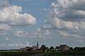
Frysk: Warstiens is in doarp yn de gemeente Ljouwert.
Nederlands: Warstiens is een dorp in de Friese gemeente Leeuwarden.
Subcategories
This category has the following 2 subcategories, out of 2 total.
Media in category "Warstiens"
The following 14 files are in this category, out of 14 total.
-
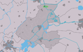
 LocatieWarstiens.png 280 × 130; 7 KB
-
 Map - NL - Boarnsterhim - Wijk 00 - Buurt 17 Warstiens.svg 375 × 375; 29 KB
-
 Map NL Boarnsterhim Warstiens.png 800 × 500; 108 KB
-
 Rijksbeschermd stads- of dorpsgezicht - Warstiens.png 2,016 × 2,267; 58 KB
-
 Warstiens wapen.svg 118 × 133; 17 KB
-
 2024 Sicht rjochting Warten.jpg 3,902 × 2,252; 3 MB
-
 Bankje-Le lit des coquillages..JPG 2,592 × 1,944; 898 KB
-
 Haven fan Warstiens.jpg 5,477 × 3,651; 14.68 MB
-
 Het cenrtum van Warstiens.JPG 2,592 × 1,944; 922 KB
-
 Het dorpje Warstiens.JPG 2,592 × 1,944; 939 KB
-
 Warstiens haventje.JPG 2,592 × 1,944; 751 KB
-
 Warstiens vlag.svg 323 × 212; 16 KB
-
 Warstiens. Een dorp in de Gemeente Leeuwarden in Friesland vlak bij Waregea.jpg 1,600 × 1,067; 303 KB
-
 Warstiens.jpg 1,600 × 1,067; 196 KB


