Category:Warrington Old Road bridge, St Helens
Jump to navigation
Jump to search
| Object location | | View all coordinates using: OpenStreetMap |
|---|
bridge in St Helens, Merseyside, England, United Kingdom  | |||||
| Upload media | |||||
| Instance of |
| ||||
|---|---|---|---|---|---|
| Location | St Helens, Merseyside, North West England, England | ||||
| Carries |
| ||||
 | |||||
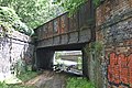
This disused skew bridge carries a branch of the St Helens and Runcorn Gap Railway running from north of Ravenhead Junction into the former Ravenhead Glass Works, now site of Tesco Extra and Totally Wicked Stadium.
Media in category "Warrington Old Road bridge, St Helens"
The following 2 files are in this category, out of 2 total.
-
 Warrington Old Road bridge, St Helens 1.jpg 5,180 × 3,434; 24.99 MB
-
 Warrington Old Road bridge, St Helens 2.jpg 4,596 × 3,009; 19.17 MB
