Category:Walsingham
Jump to navigation
Jump to search
civil parish in North Norfolk, Norfolk, England  | |||||
| Upload media | |||||
| Instance of | |||||
|---|---|---|---|---|---|
| Location | North Norfolk, Norfolk, East of England, England | ||||
| Official language | |||||
| Has part(s) | |||||
| Population |
| ||||
| Area |
| ||||
 | |||||
English: Walsingham is a village (actually two conjoined villages: Little Walsingham and Great Walsingham—the "Great" referring to its age, not size) in the English county of Norfolk. The village is famed for its religious shrines in honour of the Virgin Mary and is a major pilgrimage centre. It also contains the ruins of two medieval monastic houses.
Français : Walsingham
Subcategories
This category has the following 4 subcategories, out of 4 total.
Media in category "Walsingham"
The following 156 files are in this category, out of 156 total.
-
 A gap in the shelterbelt - geograph.org.uk - 4938378.jpg 640 × 360; 288 KB
-

-

-
 A shelterbelt of trees - geograph.org.uk - 4938389.jpg 640 × 360; 319 KB
-
 A shelterbelt of trees - geograph.org.uk - 4938421.jpg 640 × 360; 385 KB
-
 Annunciation House, Friday Market - geograph.org.uk - 6314610.jpg 5,184 × 3,888; 565 KB
-
 Baker's Belt woodland - geograph.org.uk - 5575412.jpg 640 × 480; 107 KB
-
 Barn between Walsingham and Wighton - geograph.org.uk - 5084637.jpg 5,184 × 3,456; 4.97 MB
-

-
 Clearing in Baker's Belt - geograph.org.uk - 4937731.jpg 640 × 360; 317 KB
-
 Coat of arms of Walsingham Rural District.svg 1,849 × 2,837; 5.38 MB
-
 Cock pheasant (deceased) - geograph.org.uk - 4938382.jpg 640 × 360; 339 KB
-
 Common Place - geograph.org.uk - 6731025.jpg 1,024 × 683; 217 KB
-
 Cottage on Hindringham Road, Great Walshingham - geograph.org.uk - 6638930.jpg 1,024 × 718; 173 KB
-
 Cottages near Edgar Farm - geograph.org.uk - 6637809.jpg 1,024 × 768; 202 KB
-
 Crop field, Egmere - geograph.org.uk - 6637782.jpg 1,024 × 768; 189 KB
-
 Crop fields by Blunt's Corner - geograph.org.uk - 4938367.jpg 640 × 360; 290 KB
-
 Crop fields by Blunt's Corner - geograph.org.uk - 4938497.jpg 640 × 360; 323 KB
-
 Cultivated field by Blunt's Corner - geograph.org.uk - 4938374.jpg 640 × 360; 290 KB
-
 Direction Sign – Signpost - geograph.org.uk - 6529443.jpg 855 × 641; 194 KB
-
 Eastgate Farm - geograph.org.uk - 6323661.jpg 5,184 × 3,888; 509 KB
-
 Edgar Farm - geograph.org.uk - 6637814.jpg 1,024 × 705; 156 KB
-
 Edgar Farmhouse - geograph.org.uk - 6637812.jpg 1,024 × 692; 171 KB
-
 Edgar Road near Edgar Farm - geograph.org.uk - 6637815.jpg 1,024 × 768; 194 KB
-
 Entering Great Walshingham - geograph.org.uk - 6638927.jpg 1,024 × 723; 148 KB
-
 Entering Little Walsingham - geograph.org.uk - 6637803.jpg 1,024 × 633; 224 KB
-
 Ewe and lamb - geograph.org.uk - 4938481.jpg 640 × 360; 280 KB
-
 Factory, Bunker's Hill - geograph.org.uk - 6637818.jpg 1,024 × 629; 144 KB
-
 Fakenham Road towards Walsingham - geograph.org.uk - 5557860.jpg 640 × 480; 81 KB
-
 Fakenham Road towards Walsingham - geograph.org.uk - 5557864.jpg 640 × 480; 75 KB
-
 Farmland and Tuthill Plantation near Little Walsingham - geograph.org.uk - 6069936.jpg 4,032 × 3,024; 4.56 MB
-
 Farmland east of Egmere - geograph.org.uk - 6637788.jpg 1,024 × 768; 154 KB
-
 Farmland north of Great Walsingham - geograph.org.uk - 6069982.jpg 4,032 × 3,024; 2.94 MB
-
 Field and hedge near Edgar Farm - geograph.org.uk - 6069999.jpg 4,032 × 3,024; 5.41 MB
-
 Field beside the B1105, Egmere - geograph.org.uk - 6637776.jpg 1,024 × 768; 167 KB
-
 Field east of Haggard's Lodge - geograph.org.uk - 5575637.jpg 640 × 480; 47 KB
-
 Field towards The Slug woodland - geograph.org.uk - 6638937.jpg 1,024 × 768; 210 KB
-
 Fields and hedgerows by Blunt's Corner - geograph.org.uk - 4938496.jpg 640 × 360; 276 KB
-
 Fields by Egmere Farm - geograph.org.uk - 4963790.jpg 640 × 480; 265 KB
-
 Fig. 134b Walsingham.jpg 981 × 1,521; 98 KB
-
 Footpath to Blunt's Corner - geograph.org.uk - 4938345.jpg 640 × 360; 351 KB
-
 Ford and Footbridge over the River Skiffkey - geograph.org.uk - 6314667.jpg 5,184 × 3,888; 1.01 MB
-
 Former Methodist Chapel - geograph.org.uk - 6317216.jpg 5,184 × 3,888; 482 KB
-
 Friday Cottage - geograph.org.uk - 6731027.jpg 1,024 × 683; 261 KB
-
 Friday Cottage, Friday Market - geograph.org.uk - 6314614.jpg 5,184 × 3,888; 704 KB
-
 Friday Market, Little Walsingham - geograph.org.uk - 6314604.jpg 5,184 × 3,888; 611 KB
-
 Game bird feeders beside the footpath - geograph.org.uk - 4938416.jpg 640 × 360; 281 KB
-
 Gated track off Fakenham Road - geograph.org.uk - 5557859.jpg 640 × 480; 66 KB
-
 Grain field at Bunker's Hill - geograph.org.uk - 5850681.jpg 1,600 × 1,067; 482 KB
-
 Great Walsingham village sign - geograph.org.uk - 6707864.jpg 2,272 × 2,272; 1.33 MB
-
 Great Walsingham village sign - geograph.org.uk - 6707868.jpg 4,608 × 3,072; 5.54 MB
-
 Halfway between Wells and Fakenham in Norfolk - geograph.org.uk - 5293122.jpg 4,320 × 3,240; 5.5 MB
-
 Heading south through Baker's Belt - geograph.org.uk - 5575636.jpg 640 × 480; 112 KB
-

-
 Hen pheasant (deceased) - geograph.org.uk - 4938419.jpg 640 × 360; 349 KB
-
 High Street, Little Walsingham - geograph.org.uk - 6314385.jpg 5,184 × 3,888; 575 KB
-
 Hindringham Road towards Great Walshingham - geograph.org.uk - 6638920.jpg 1,024 × 768; 120 KB
-
 Hindringham Road, Great Walsingham - geograph.org.uk - 6323658.jpg 5,184 × 3,888; 655 KB
-
 K6 telephone box, Great Walshingham - geograph.org.uk - 6638934.jpg 1,024 × 621; 186 KB
-
 Lane near Edgar Farm - geograph.org.uk - 6070004.jpg 4,032 × 3,024; 2.58 MB
-
 Lane towards Egmere - geograph.org.uk - 5575638.jpg 640 × 480; 50 KB
-
 Lane towards Great Snoring - geograph.org.uk - 6638938.jpg 1,024 × 768; 212 KB
-
 Large field, Walsingham - geograph.org.uk - 6637800.jpg 1,024 × 768; 150 KB
-
 Little Walsingham - Common Place - geograph.org.uk - 6459150.jpg 1,800 × 1,200; 287 KB
-
 Little Walsingham Narrow Gauge Railway Station - geograph.org.uk - 6314629.jpg 5,184 × 3,888; 413 KB
-
 Lodge off Fakenham Road - geograph.org.uk - 5557857.jpg 640 × 480; 77 KB
-
 Memorial to Sqn Ldr. H P Lee-Warner, DFC, AFC, Pilot - geograph.org.uk - 6506474.jpg 2,296 × 1,240; 635 KB
-
 Minor road from Egmere towards Little Walsingham - geograph.org.uk - 6637794.jpg 1,024 × 768; 301 KB
-
 Minor road towards Little Walsingham - geograph.org.uk - 6637802.jpg 1,024 × 768; 233 KB
-
 Minor road, Egmere - geograph.org.uk - 6637786.jpg 800 × 600; 94 KB
-
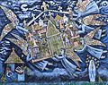 Miracle of the holy house of walsingham by Brian Whelan.jpg 2,538 × 2,016; 798 KB
-
 Modern pilgrim badge (FindID 508764).jpg 4,426 × 2,362; 963 KB
-
 Neglected barn east of Egmere - geograph.org.uk - 6637792.jpg 1,024 × 710; 145 KB
-
 New memorial for RAF North Creake - geograph.org.uk - 6812607.jpg 3,456 × 2,592; 3.71 MB
-
 Newly planted crop field off The Street - geograph.org.uk - 6638941.jpg 1,024 × 768; 207 KB
-
 North Creake Airfield (disused) - geograph.org.uk - 5850684.jpg 1,600 × 979; 259 KB
-
 Old airfield buildings - RAF North Creake - geograph.org.uk - 4670291.jpg 1,600 × 1,064; 313 KB
-
 Old concreted road - geograph.org.uk - 4938354.jpg 640 × 360; 262 KB
-
 Old road long since closed - geograph.org.uk - 4938343.jpg 640 × 360; 368 KB
-
 Overgrown entrance porch - geograph.org.uk - 4945684.jpg 640 × 480; 574 KB
-

-
-
 Pheasant feeder beside the footpath - geograph.org.uk - 4938417.jpg 640 × 360; 274 KB
-
 Pilgrims Returning to St Mary's - geograph.org.uk - 6314582.jpg 5,184 × 3,888; 436 KB
-
 Pilgrims Returning to St Mary's - geograph.org.uk - 6314585.jpg 5,184 × 3,888; 494 KB
-
 Pilgrims Returning to St Mary's - geograph.org.uk - 6314589.jpg 5,184 × 3,888; 500 KB
-
 Pilgrims Returning to St Mary's - geograph.org.uk - 6314593.jpg 5,184 × 3,888; 545 KB
-
 Pilgrims Returning to St Mary's - geograph.org.uk - 6314599.jpg 5,184 × 3,888; 617 KB
-
 Pink cottage, Egmere - geograph.org.uk - 6637777.jpg 1,024 × 768; 162 KB
-
 Potato field just off Edgar Road - geograph.org.uk - 6637805.jpg 640 × 480; 77 KB
-
 Public footpath to Blunt's Corner - geograph.org.uk - 4938409.jpg 640 × 360; 240 KB
-
 RAF North Creake Memorial and Roll of Honour - geograph.org.uk - 6812610.jpg 3,456 × 2,592; 4.24 MB
-
 Railway Bridge over Road - geograph.org.uk - 6314635.jpg 5,184 × 3,888; 543 KB
-
 Rat trap - geograph.org.uk - 4938487.jpg 640 × 360; 343 KB
-
 Rat trap - geograph.org.uk - 4938488.jpg 640 × 487; 444 KB
-
 Redwings feeding - geograph.org.uk - 5616179.jpg 1,589 × 1,192; 435 KB
-
 Road traversing Baker's Belt - geograph.org.uk - 4937737.jpg 640 × 360; 368 KB
-
 Row of Cottages on the outskirts of Little Walsingham - geograph.org.uk - 6314620.jpg 5,184 × 3,888; 462 KB
-
 Sandy Lane near Little Walsingham - geograph.org.uk - 6069929.jpg 4,032 × 3,024; 5.33 MB
-
 Scrambled egg - geograph.org.uk - 4938492.jpg 640 × 418; 459 KB
-
 Sheep and solar panels - geograph.org.uk - 4938482.jpg 640 × 454; 375 KB
-
 Sheep grazing in the solar farm - geograph.org.uk - 4938479.jpg 640 × 360; 261 KB
-
 Silos, Bunkers Hill Mill - geograph.org.uk - 6637819.jpg 1,024 × 768; 106 KB
-

-
 Spigot mortar emplacement - geograph.org.uk - 4963701.jpg 640 × 562; 647 KB
-
 St Peter's Church, Great Walsingham - geograph.org.uk - 6459162.jpg 1,799 × 1,199; 404 KB
-
 St. Peter's Church, Great Walsingham - geograph.org.uk - 6317219.jpg 5,184 × 3,888; 585 KB
-
 St. Peter's Church, Great Walsingham - geograph.org.uk - 6317221.jpg 5,184 × 3,888; 472 KB
-
 Stubble field off Hindringham Road - geograph.org.uk - 6638919.jpg 1,024 × 768; 202 KB
-
 Stubble field off Walsingham Road - geograph.org.uk - 5557878.jpg 640 × 480; 60 KB
-
 Stubble field, Great Walshingham - geograph.org.uk - 6638923.jpg 1,024 × 768; 159 KB
-
 The end of the old SW-NE runway - geograph.org.uk - 4938424.jpg 640 × 360; 284 KB
-
-
 The remains of a Tortoise stove - geograph.org.uk - 4963720.jpg 640 × 622; 672 KB
-
 The start of a public footpath - geograph.org.uk - 4938338.jpg 640 × 360; 346 KB
-
 The Street towards Great Snoring - geograph.org.uk - 6638942.jpg 1,024 × 768; 175 KB
-
 Timber Framed House, Great Walsingham - geograph.org.uk - 6314659.jpg 5,184 × 3,888; 669 KB
-
 Track in Baker's Belt - geograph.org.uk - 4937733.jpg 640 × 360; 394 KB
-
 Track off Walsingham Road - geograph.org.uk - 5557900.jpg 640 × 480; 80 KB
-
 Tree beside footpath to Blunt's Corner - geograph.org.uk - 4938493.jpg 640 × 360; 308 KB
-
 Tree line - geograph.org.uk - 6420022.jpg 800 × 533; 120 KB
-
 Tree lined lane near Great Walsingham - geograph.org.uk - 6069973.jpg 4,032 × 3,024; 3.44 MB
-
 Type FW3-24 pillbox (entrance gate) - geograph.org.uk - 4963692.jpg 480 × 640; 439 KB
-
 Type FW3-24 pillbox - geograph.org.uk - 4963684.jpg 640 × 480; 454 KB
-
 Type FW3-24 pillbox - geograph.org.uk - 4963687.jpg 640 × 360; 333 KB
-
 Type FW3-24 pillbox - geograph.org.uk - 4963696.jpg 640 × 360; 271 KB
-
 Unnamed lane through Baker's Belt - geograph.org.uk - 4937728.jpg 640 × 360; 384 KB
-
 View along the former perimeter track - geograph.org.uk - 4938387.jpg 640 × 360; 231 KB
-
 View into a WW2 building - geograph.org.uk - 4945685.jpg 640 × 514; 376 KB
-
 View into a WW2 building - geograph.org.uk - 4945687.jpg 480 × 640; 397 KB
-
 View into a WW2 building - geograph.org.uk - 4945691.jpg 640 × 480; 324 KB
-
 View into a WW2 building - geograph.org.uk - 4945692.jpg 640 × 491; 406 KB
-
 View into a WW2 building - geograph.org.uk - 4945695.jpg 640 × 480; 455 KB
-
 Walsingham arrival, 1983 - geograph.org.uk - 6393110.jpg 1,024 × 1,024; 1.39 MB
-
 Walsingham Road towards Wells - geograph.org.uk - 5557903.jpg 640 × 480; 104 KB
-
 Walsingham Road, Egmere - geograph.org.uk - 6637781.jpg 1,024 × 768; 154 KB
-
 Walsingham station - geograph.org.uk - 5084627.jpg 5,184 × 3,456; 7.45 MB
-
 War Memorial, Little Walsingham - geograph.org.uk - 6314574.jpg 5,184 × 3,888; 791 KB
-
 Wells Road - geograph.org.uk - 5557877.jpg 640 × 480; 56 KB
-
 Winter cereal near Edgar Farm - geograph.org.uk - 6069994.jpg 4,032 × 3,024; 3.21 MB
-
 Woodland clearing, Baker's Belt - geograph.org.uk - 5575414.jpg 640 × 480; 65 KB
-
 WW2 Ammunition lock-up (interior) - geograph.org.uk - 4963811.jpg 640 × 563; 509 KB
-
 WW2 Ammunition lock-up - geograph.org.uk - 4963797.jpg 640 × 480; 606 KB
-
 WW2 Ammunition lock-up - geograph.org.uk - 4963798.jpg 640 × 531; 606 KB
-
 WW2 Ammunition lock-up - geograph.org.uk - 4963800.jpg 640 × 480; 531 KB
-
 WW2 Ammunition lock-up - geograph.org.uk - 4963801.jpg 640 × 480; 585 KB
-
 WW2 Ammunition lock-up - geograph.org.uk - 4963804.jpg 640 × 480; 624 KB
-
 WW2 Ammunition lock-up - geograph.org.uk - 4963806.jpg 640 × 516; 584 KB
-
 WW2 Ammunition lock-up - geograph.org.uk - 4963807.jpg 480 × 640; 489 KB
-
 WW2 Ammunition lock-up - geograph.org.uk - 4963809.jpg 640 × 480; 551 KB
-
 WW2 Ammunition lock-up - geograph.org.uk - 4963810.jpg 640 × 565; 632 KB
-
 WW2 concrete road - geograph.org.uk - 4938351.jpg 640 × 360; 224 KB
-
 WW2 Home Guard shelter (interior view) - geograph.org.uk - 4963715.jpg 640 × 480; 456 KB
-
 WW2 Home Guard shelter (interior view) - geograph.org.uk - 4963718.jpg 640 × 480; 460 KB
-
 WW2 Home Guard shelter - geograph.org.uk - 4963709.jpg 640 × 480; 543 KB
-


_-_geograph.org.uk_-_4938382.jpg)


_-_geograph.org.uk_-_4938419.jpg)


_-_geograph.org.uk_-_5850684.jpg)


_-_geograph.org.uk_-_4963692.jpg)


_-_geograph.org.uk_-_4963811.jpg)


_-_geograph.org.uk_-_4963715.jpg)
_-_geograph.org.uk_-_4963718.jpg)


.jpg)