Category:Wall of Nations (Marcali)
Jump to navigation
Jump to search
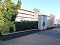
English: : Wall of Nations by Csilla Király (2015 public art) - Kulturális Korzó (~Cultural Corso?), Múzeum Alley, Marcali, Somogy County, Hungary.
Magyar: : Gabion rendszerű padok között a Nemzetek Fala 'Európai Uniós országok csillagtérképe' ? ( Király Csilla dekoratőr 2015-ös munkája.) https://muvhaz-marcali.hu/index.php/intezmenyunk/nemzetek-fala - Somogy megye, Marcali, Múzeum köz/Kulturális Korzó
| Object location | | View all coordinates using: OpenStreetMap |
|---|
Media in category "Wall of Nations (Marcali)"
The following 2 files are in this category, out of 2 total.
-
 Gabion bench(es) and the Wall of Nations, 2020 Marcali.jpg 2,272 × 1,704; 985 KB
-
 Wall of Nations by Csilla Király, 2020 Marcali.jpg 1,704 × 2,272; 1.08 MB
_and_the_Wall_of_Nations,_2020_Marcali.jpg)
