Category:Walgherton
Jump to navigation
Jump to search
English: Walgherton is a village (at ) and civil parish in the unitary authority of Cheshire East and the ceremonial county of Cheshire, England. The village lies 3½ miles to the south east of Nantwich and 4½ miles to the south of Crewe. It also includes the settlement of Hussey's Nook. Nearby villages include Hatherton, Stapeley and Wybunbury. The A51 road runs east–west through the parish.
village and civil parish in Cheshire East, Cheshire, UK  | |||||
| Upload media | |||||
| Instance of | |||||
|---|---|---|---|---|---|
| Location | Cheshire East, Cheshire, North West England, England | ||||
| Population |
| ||||
 | |||||
Media in category "Walgherton"
The following 26 files are in this category, out of 26 total.
-
 A51 at Back Lane junction - geograph.org.uk - 2728749.jpg 640 × 480; 51 KB
-

-
 A51 at Walgherton crossroads - geograph.org.uk - 6575988.jpg 1,024 × 769; 224 KB
-
 A51 from the entrance to Manor Farm - geograph.org.uk - 2728761.jpg 640 × 480; 65 KB
-
 A51 London Road nears Walgherton boundary - geograph.org.uk - 6575984.jpg 1,024 × 778; 184 KB
-
 A51 near London Road Farm - geograph.org.uk - 2728789.jpg 640 × 480; 64 KB
-
 A51 north of Walgherton - geograph.org.uk - 2728758.jpg 640 × 480; 87 KB
-
 Back Lane, Wynbunbury - geograph.org.uk - 2674087.jpg 640 × 480; 110 KB
-
 Crewe Road at Dagfields Farm - geograph.org.uk - 2674094.jpg 640 × 480; 103 KB
-
 Crewe Road southwest of The Boar's Head - geograph.org.uk - 2674091.jpg 640 × 480; 184 KB
-
 Forge Brook from bridge - geograph.org.uk - 416548.jpg 640 × 480; 118 KB
-
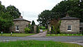
 Former lodges to Doddington Park, Walgherton - geograph.org.uk - 4981280.jpg 1,600 × 899; 393 KB
-
 Lea Forge - geograph.org.uk - 6407165.jpg 800 × 533; 135 KB
-
 North Lodges, Doddington Hall.jpg 640 × 365; 145 KB
-
 Sign on the A51 - geograph.org.uk - 1211758.jpg 600 × 450; 359 KB
-
 Stile nr Oat Eddish Farm, Walgherton.jpg 2,000 × 1,333; 300 KB
-
 Thatchers, Walgherton.jpg 2,000 × 1,333; 290 KB
-
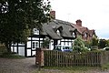 Thatchers. Walgherton.jpg 3,456 × 2,304; 2.11 MB
-
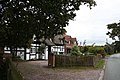
 The Boar's Head inn at Walgherton - geograph.org.uk - 4981286.jpg 1,600 × 899; 268 KB
-
 The Boar's Head pub, Walgherton - geograph.org.uk - 2728753.jpg 640 × 480; 78 KB
-
 The Boar's Head, Walgherton - geograph.org.uk - 2674089.jpg 640 × 480; 125 KB
-
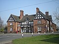 The Boar's Head, Walgherton.jpg 600 × 450; 262 KB
-
 Bridge over Brook - geograph.org.uk - 461070.jpg 640 × 480; 118 KB
-

-
 Stapeley Water Gardens - geograph.org.uk - 328633.jpg 570 × 418; 126 KB
-
 Stiles on footpath to Wybunbury - geograph.org.uk - 423413.jpg 640 × 480; 80 KB


