Category:Waalbandijk 68, Echteld
Jump to navigation
Jump to search
| Object location | | View all coordinates using: OpenStreetMap |
|---|
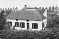
farmhouse in Neder-Betuwe, Netherlands  | |||||
| Upload media | |||||
| Instance of | |||||
|---|---|---|---|---|---|
| Location | Echteld, Gelderland, Netherlands | ||||
| Street address |
| ||||
| Located on street |
| ||||
| Heritage designation |
| ||||
 | |||||
Den Yver
|
This is a category about rijksmonument number 14270
|
| Address |
|
Media in category "Waalbandijk 68, Echteld"
The following 9 files are in this category, out of 9 total.
-
 Achtergevel - Echteld - 20065927 - RCE.jpg 1,200 × 804; 226 KB
-
 Den IJver", aanzicht - Echteld - 20065923 - RCE.jpg 1,200 × 807; 248 KB
-
 Echteld Waalbandijk 68 1.jpg 3,264 × 2,448; 1.43 MB
-
 Echteld Waalbandijk 68 2.jpg 3,264 × 2,448; 1.45 MB
-
 Echteld Waalbandijk 68 3.jpg 2,448 × 3,264; 1.62 MB
-
 Echteld Waalbandijk 68 4.jpg 3,264 × 2,448; 1.6 MB
-
 Overzicht - Echteld - 20065924 - RCE.jpg 1,200 × 803; 266 KB
-
 Rechter zijgevel - Echteld - 20065926 - RCE.jpg 1,200 × 804; 262 KB
-
 Voor- en rechterzijgevel - Echteld - 20065925 - RCE.jpg 1,200 × 792; 220 KB


