Category:Waalbandijk 68, Afferden
Jump to navigation
Jump to search
| Object location | | View all coordinates using: OpenStreetMap |
|---|
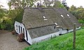
farmhouse in Druten, Netherlands _Rijksmonument_14156_Waalbandijk_68_(dijkzijde)_gebouwd.JPG) | |||||
| Upload media | |||||
| Instance of | |||||
|---|---|---|---|---|---|
| Location | Afferden, Gelderland, Gelderland, Netherlands | ||||
| Street address |
| ||||
| Located on street |
| ||||
| Heritage designation |
| ||||
 | |||||
|
This is a category about rijksmonument number 14156
|
| Address |
|
Media in category "Waalbandijk 68, Afferden"
The following 7 files are in this category, out of 7 total.
-
 Afferden (Druten) Rijksmonument 14156 (vanaf de tuin) Waalbandijk 68.JPG 3,648 × 2,736; 4.27 MB
-
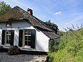 Afferden (Druten) Rijksmonument 14156 Waalbandijk 68 (dijkzijde) gebouwd.JPG 3,648 × 2,736; 4.21 MB
-
 Afferden (Druten) Rijksmonument 14156 Waalbandijk 68 (vanaf de dijk).JPG 3,648 × 2,736; 4.32 MB
-
 Afferden RM Waalbandijk 68.jpg 4,137 × 2,456; 5.24 MB
-
 Overzicht - Afferden - 20005104 - RCE.jpg 1,200 × 949; 232 KB
-
 Vooraanzicht - Afferden - 20005103 - RCE.jpg 1,200 × 788; 201 KB
-
 Voorgevel - Afferden - 20005105 - RCE.jpg 1,200 × 950; 224 KB
_Rijksmonument_14156_(vanaf_de_tuin)_Waalbandijk_68.JPG)
_Rijksmonument_14156_Waalbandijk_68_(vanaf_de_dijk).JPG)


