Category:WWII mass graves in Kalantaivka
Jump to navigation
Jump to search
| Object location | | View all coordinates using: OpenStreetMap |
|---|
 | |||||
| Upload media | |||||
| Instance of | |||||
|---|---|---|---|---|---|
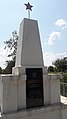
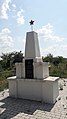
| Location | Kalantaivka, Rozdilna urban hromada, Rozdilna Raion, Odesa Oblast, Ukraine | ||||
| Heritage designation |
| ||||
 | |||||
Media in category "WWII mass graves in Kalantaivka"
The following 8 files are in this category, out of 8 total.
-
 WWII mass grave in Kalantaivka 05.jpg 2,322 × 4,128; 1.99 MB
-
 WWII mass graves in Kalantaivka 01.jpg 4,128 × 2,322; 4.58 MB
-
 WWII mass graves in Kalantaivka 02.jpg 4,128 × 2,322; 4.37 MB
-
 WWII mass graves in Kalantaivka 03.jpg 2,322 × 4,128; 1.42 MB
-
 WWII mass graves in Kalantaivka 04.jpg 2,322 × 4,128; 1.38 MB
-
 WWII mass graves in Kalantaivka 06.jpg 2,322 × 4,128; 1.92 MB
-
 WWII mass graves in Kalantaivka 07.jpg 2,322 × 4,128; 1.8 MB
-
 WWII mass graves in Kalantaivka 08.jpg 2,322 × 4,128; 1.63 MB


