Category:WWII mass graves in Balkove
Jump to navigation
Jump to search
| Object location | | View all coordinates using: OpenStreetMap |
|---|
 | |||||
| Upload media | |||||
| Instance of | |||||
|---|---|---|---|---|---|
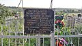
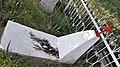
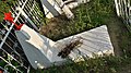
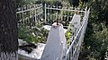
| Location | Balkove, Rozdilna urban hromada, Rozdilna Raion, Odesa Oblast, Ukraine | ||||
| Heritage designation |
| ||||
 | |||||
Media in category "WWII mass graves in Balkove"
The following 11 files are in this category, out of 11 total.
-
 WWII mass graves in Balkove 01.jpg 4,128 × 2,322; 3.91 MB
-
 WWII mass graves in Balkove 02.jpg 4,128 × 2,322; 4.39 MB
-
 WWII mass graves in Balkove 03.jpg 4,128 × 2,322; 4.42 MB
-
 WWII mass graves in Balkove 04.jpg 2,320 × 4,128; 2.65 MB
-
 WWII mass graves in Balkove 05.jpg 4,128 × 2,322; 4.34 MB
-
 WWII mass graves in Balkove 06.jpg 2,320 × 4,128; 2.53 MB
-
 WWII mass graves in Balkove 07.jpg 4,128 × 2,322; 4.01 MB
-
 WWII mass graves in Balkove 08.jpg 2,322 × 4,128; 2.84 MB
-
 WWII mass graves in Balkove 09.jpg 4,128 × 2,322; 4.8 MB
-
 WWII mass graves in Balkove 10.jpg 4,128 × 2,322; 5.23 MB
-
 WWII mass graves in Balkove 11.jpg 4,128 × 2,322; 4.35 MB


