Category:Wüste Kirche (Söllnitz)
Jump to navigation
Jump to search
| Object location | | View all coordinates using: OpenStreetMap |
|---|
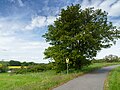
natural monument area in Wurzen Municipality, Saxony, Germany; Biotope near a former church in the river Mulde Aue  | |||||
| Upload media | |||||
| Instance of | |||||
|---|---|---|---|---|---|
| Part of | |||||
| Location | Wurzen, Landkreis Leipzig, Saxony, Germany | ||||
| Heritage designation | |||||
| Start time |
| ||||
| Area |
| ||||
 | |||||
Media in category "Wüste Kirche (Söllnitz)"
The following 13 files are in this category, out of 13 total.
-
 Dehnitz Wueste Kirche (Soellnitz)-01.jpg 5,333 × 4,000; 6.65 MB
-
 Dehnitz Wueste Kirche (Soellnitz)-02.jpg 3,835 × 5,113; 6.11 MB
-
 Dehnitz Wueste Kirche (Soellnitz)-03.jpg 5,333 × 4,000; 7.86 MB
-
 Dehnitz Wueste Kirche (Soellnitz)-04.jpg 5,333 × 4,000; 9.14 MB
-
 Dehnitz Wueste Kirche (Soellnitz)-05.jpg 6,000 × 4,000; 8.36 MB
-
 Dehnitz Wueste Kirche (Soellnitz)-06.jpg 5,333 × 4,000; 9.92 MB
-
 Wüste Kirche - Blick auf Mulde und Altes Wasser Pausitz.jpg 4,032 × 3,024; 6.05 MB
-
 Wüste Kirche - Blick auf Mulde und Planitzwald 01.jpg 4,032 × 3,024; 5.46 MB
-
 Wüste Kirche - Blick auf Mulde und Planitzwald 02.jpg 4,032 × 3,024; 5.23 MB
-
 Wüste Kirche - Blick auf Muldeaue.jpg 4,032 × 3,024; 5.79 MB
-
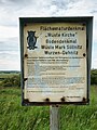
 Wüste Kirche - FND-Beschilderung 01.jpg 4,032 × 3,024; 7.99 MB
-
 Wüste Kirche - FND-Beschilderung 02.jpg 4,032 × 3,024; 7.63 MB
-
 Wüste Kirche - Mauerreste und Trockenrasen.jpg 4,032 × 3,024; 7.72 MB
-01.jpg)
-02.jpg)
-03.jpg)
-04.jpg)
-05.jpg)
-06.jpg)


