Category:Wâlterswâld
Jump to navigation
Jump to search
| Object location | | View all coordinates using: OpenStreetMap |
|---|
village in the Dutch province of Friesland     | |||||
| Upload media | |||||
| Instance of | |||||
|---|---|---|---|---|---|
| Location | Dantumadiel, Friesland, Netherlands | ||||
| official website | |||||
 | |||||
English: Wâlterswâld is a village in Dantumadiel, a municipality in the Dutch province of Friesland.
Frysk: Wâlterswâld is in doarp yn Dantumadiel.
Nederlands: Wâlterswâld (Nederlands, niet-officieel: Wouterswoude) is een dorp in de Friese gemeente Dantumadiel.
Subcategories
This category has the following 3 subcategories, out of 3 total.
Media in category "Wâlterswâld"
The following 6 files are in this category, out of 6 total.
-
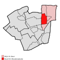 Map - NL - Dantumadeel - Wijk 01 Oost - Buurt 01 Wouterswoude.svg 375 × 375; 23 KB
-

-
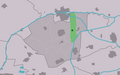 Map NL Dantumadiel Wâlterswâld.png 800 × 500; 54 KB
-
 Wâlterswâld wapen.svg 165 × 184; 255 KB
-
 20200612 paard-en ruiter Ludema State.jpg 4,408 × 2,939; 3.08 MB
-
 Monument voor de cichoreiteelt.JPG 2,048 × 1,536; 557 KB


