Category:Vredeskerk (Delft)
Jump to navigation
Jump to search
| Object location | | View all coordinates using: OpenStreetMap |
|---|
church building in Delft, Netherlands  | |||||
| Upload media | |||||
| Instance of | |||||
|---|---|---|---|---|---|
| Part of | |||||
| Location | Delft, South Holland, Netherlands | ||||
| Street address |
| ||||
| Located on street |
| ||||
| Heritage designation |
| ||||
| Religion or worldview | |||||
| Maximum capacity |
| ||||
 | |||||
| Kerk: |
| ||
| Pastorie: |
| ||
| Zusterhuis: |
|
| Address |
|
Nederlands: Allerheiligst Sacrament- of Vredeskerk - anno 1940
Media in category "Vredeskerk (Delft)"
The following 11 files are in this category, out of 11 total.
-
 Delft - Allerheiligen kerk.jpg 1,536 × 2,048; 1.34 MB
-
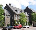 Delft - Nassaulaan 2.jpg 2,052 × 1,728; 1.08 MB
-
 Delft - Simonsstraat 113-117.jpg 2,592 × 1,944; 1.02 MB
-
 Delft Vredeskerk seen from the southwest.jpg 4,000 × 5,824; 13.53 MB
-

-
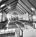
 Interieur, overzicht richting het altaar - Delft - 20334354 - RCE.jpg 1,183 × 1,200; 277 KB
-
 Interieur, overzicht richting het orgel - Delft - 20334355 - RCE.jpg 1,190 × 1,200; 328 KB
-
 Overzicht zuidgevel met zicht op de kerktoren - Delft - 20334353 - RCE.jpg 1,184 × 1,200; 337 KB
-
 Vredeskerk Delft 2020 2.jpg 6,048 × 4,024; 13.65 MB
-
 Vredeskerk Delft 2020.jpg 4,024 × 6,048; 11.76 MB
-
 Vredeskerk, Delft (2012) - panoramio.jpg 1,440 × 2,174; 800 KB


_-_panoramio.jpg)