Category:Vredefort Dome
Appearance
|
This place is a UNESCO World Heritage Site, listed as
Vredefort Dome.
|
largest verified impact crater on earth, dating from the Paleoproterozoic Era | |||||
| Upload media | |||||
| Instance of | |||||
|---|---|---|---|---|---|
| Named after | |||||
| Location |
| ||||
| Has part(s) |
| ||||
| Heritage designation |
| ||||
| Time of discovery or invention |
| ||||
| Diameter |
| ||||
| Area |
| ||||
| Said to be the same as | Vredefort Impact Crater | ||||
 | |||||
Media in category "Vredefort Dome"
The following 40 files are in this category, out of 40 total.
-
Map of Vredefort dome.jpg 10,000 × 8,319; 1.63 MB
-
South African Geology - Schwarz - 1912 Fig 51.png 1,516 × 1,301; 1.22 MB
-
The Quarterly journal of the Geological Society of London (1898) (14778506372).jpg 3,038 × 2,536; 1.53 MB
-
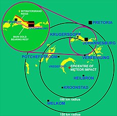
Vredefort crater & Witwatersrand.png 4,226 × 3,956; 383 KB
-
Vredefort crater & Witwatersrand2.png 4,226 × 3,956; 276 KB
-
Witwatersrand outcrops 2.jpg 10,000 × 9,902; 2.62 MB
-
Aasvoelkop - panoramio.jpg 2,048 × 1,536; 1.53 MB
-
Aasvoelkop - Vredefort dome - panoramio.jpg 2,048 × 1,536; 1.5 MB
-
Aasvoelkop and church - panoramio.jpg 1,024 × 681; 236 KB
-
Aasvoelkop.jpg 4,032 × 3,024; 4.91 MB
-
Church with Aasvoelkop in the background - panoramio.jpg 2,048 × 1,536; 1.19 MB
-
Fonteinplaas - panoramio.jpg 2,048 × 1,536; 1.23 MB
-
Fonteinplaas church - panoramio.jpg 2,048 × 1,536; 1.3 MB
-
Pseudotachylite Breccia of Vredefort in South Africa.jpg 1,280 × 851; 418 KB
-
Shocked zircon 02.jpg 2,323 × 2,869; 3.05 MB
-
Shocked zircon.jpg 6,630 × 5,075; 16.68 MB
-
Students in the field.jpg 4,032 × 3,024; 2.02 MB
-
Vaal river - from Aasvoelkop - panoramio.jpg 1,024 × 681; 250 KB
-
Vaal River, Vredefort Dome.jpg 3,525 × 2,133; 2.24 MB
-
Venterskroon, North West province, South Africa.jpg 3,222 × 2,053; 6.37 MB
-
Vredefort crater cross section 2.png 3,324 × 1,024; 131 KB
-
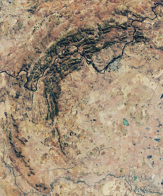
Vredefort Crater, South Africa, OLI satellite image, 27 June 2018 cropped.png 1,340 × 1,609; 5.58 MB
-
Vredefort Crater, South Africa, OLI satellite image, 27 June 2018.jpg 3,684 × 5,928; 9.32 MB
-
Vredefort crater.jpg 288 × 287; 28 KB
-
Vredefort dome - Vaal River - panoramio.jpg 2,048 × 1,536; 1.26 MB
-
Vredefort dome - world heritage site - panoramio.jpg 2,048 × 1,536; 1.47 MB
-
Vredefort Dome Information Centre.jpg 2,828 × 1,817; 3.24 MB
-
Vredefort Dome sign.jpg 3,228 × 2,189; 2.32 MB
-
Vredefort Dome STS51I-33-56AA.jpg 2,124 × 2,137; 1.93 MB
-
Vredefort Dome Vredefort-001.jpg 1,920 × 995; 770 KB
-
Vredefort Dome Vredefort-002.jpg 1,920 × 1,080; 907 KB
-
Vredefort dome world heritage site - panoramio.jpg 1,024 × 681; 229 KB
-
Vredefort Dome-113482.jpg 2,048 × 1,536; 1.06 MB
-
Vredefort Dome-113484.jpg 2,048 × 1,536; 1.09 MB
-
Vredefort Dome-113487.jpg 2,048 × 1,536; 1.16 MB
-
Vredefort Dome-113488.jpg 2,048 × 1,536; 1.16 MB
-
Vredefort Free State Wikivoyage Banner.jpg 3,969 × 567; 463 KB
-
Vredefort-arrow.jpg 641 × 524; 47 KB
-
Vredefort.jpg 1,024 × 768; 266 KB
-
Young geologist.jpg 4,032 × 3,024; 3.18 MB


