Category:Voorzorg (Leidschendam)
Jump to navigation
Jump to search
| Object location | | View all coordinates using: OpenStreetMap |
|---|
 | |||||
| Upload media | |||||
| Instance of | |||||
|---|---|---|---|---|---|
| Part of | |||||
| Location | Leidschendam, Leidschendam-Voorburg, South Holland, Netherlands | ||||
| Street address |
| ||||
| Located on street |
| ||||
| Heritage designation |
| ||||
 | |||||
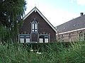
Nederlands: Hoeve Voorzorg
|
This is a category about rijksmonumentcomplex number 510302
|
Boerderij
|
This is a category about rijksmonument number 510303
|
Schuur
|
This is a category about rijksmonument number 510304
|
| Address |
|
Media in category "Voorzorg (Leidschendam)"
The following 4 files are in this category, out of 4 total.
-
 Leidschendam - Wilsveen 2 (schuur).jpg 2,240 × 1,660; 1.13 MB
-
 Overzicht voorgevel - Leidschendam - 20365437 - RCE.jpg 1,200 × 1,200; 378 KB
-
 Wilsveen 2, boerderij, farm, Netherlands(2).jpg 1,275 × 848; 229 KB
-
 Wilsveen 2, boerderij, farm, Netherlands.jpg 1,333 × 848; 226 KB
.jpg)

.jpg)