Category:Voorstreek 12, Leeuwarden
Jump to navigation
Jump to search
| Object location | | View all coordinates using: OpenStreetMap |
|---|
 | |||||
| Upload media | |||||
| Instance of |
| ||||
|---|---|---|---|---|---|
| Location | Leeuwarden, Friesland, Netherlands | ||||
| Located on street | |||||
| Heritage designation |
| ||||
 | |||||
|
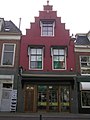
This is a category about rijksmonument number 24432
|
| Address |
|
Media in category "Voorstreek 12, Leeuwarden"
The following 3 files are in this category, out of 3 total.
-
 Leeuwarden Voorstreek 12.jpg 1,712 × 2,288; 1.75 MB
-
 RM24432 Leeuwarden - Voorstreek 12.jpg 1,944 × 2,592; 1.29 MB
-
 Voorgevels - Leeuwarden - 20132936 - RCE.jpg 809 × 1,200; 153 KB

