Category:Voorstreek 119 (Sloten, Friesland)
Jump to navigation
Jump to search
| Object location | | View all coordinates using: OpenStreetMap |
|---|
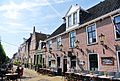
building in Gaasterlân-Sleat, Netherlands  | |||||
| Upload media | |||||
| Instance of | |||||
|---|---|---|---|---|---|
| Location | Sloten, De Fryske Marren, Friesland, Netherlands | ||||
| Street address |
| ||||
| Located on street | |||||
| Heritage designation |
| ||||
 | |||||
|
This is a category about rijksmonument number 33873
|
| Address |
|
Media in category "Voorstreek 119 (Sloten, Friesland)"
The following 5 files are in this category, out of 5 total.
-
 8556 Sloten, Netherlands - panoramio (11).jpg 2,048 × 1,375; 738 KB
-
 Overzicht Koestraat naar het westen - Sloten - 20201063 - RCE.jpg 1,200 × 825; 234 KB
-
 Overzicht naar het noord-westen - Sloten - 20201087 - RCE.jpg 1,200 × 810; 247 KB
-
 Voorgevels - Sloten - 20201232 - RCE.jpg 802 × 1,200; 208 KB
-
 Voorstreek119 Sloten.jpg 3,648 × 2,736; 918 KB
.jpg)


