Category:Voorstreek 116 (Sloten, Friesland)
Jump to navigation
Jump to search
| Object location | | View all coordinates using: OpenStreetMap |
|---|
building in Gaasterlân-Sleat, Netherlands  | |||||
| Upload media | |||||
| Instance of | |||||
|---|---|---|---|---|---|
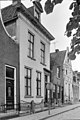
| Location | Sloten, De Fryske Marren, Friesland, Netherlands | ||||
| Street address |
| ||||
| Located on street | |||||
| Heritage designation |
| ||||
 | |||||
Nederlands: Voorstreek 116, Sloten, Friesland
|
This is a category about rijksmonument number 33877
|
| Address |
|
Media in category "Voorstreek 116 (Sloten, Friesland)"
The following 22 files are in this category, out of 22 total.
-
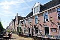 8556 Sloten, Netherlands - panoramio (11).jpg 2,048 × 1,375; 738 KB
-
 8556 Sloten, Netherlands - panoramio (17).jpg 2,048 × 1,375; 497 KB
-
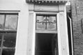
 Bovenlicht achterdeur - Sloten - 20201225 - RCE.jpg 1,200 × 786; 113 KB
-
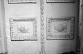
 Details voorgevel - Sloten - 20201219 - RCE.jpg 1,200 × 803; 160 KB
-
 Details voorgevel - Sloten - 20201220 - RCE.jpg 786 × 1,200; 169 KB
-
 Details voorgevel - Sloten - 20201221 - RCE.jpg 1,200 × 789; 144 KB
-
 Details voorgevel - Sloten - 20351927 - RCE.jpg 787 × 1,200; 165 KB
-
 Details voorgevel - Sloten - 20351928 - RCE.jpg 1,200 × 786; 123 KB
-
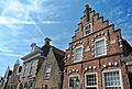
 Overzicht voorgevels - Sloten - 20334282 - RCE.jpg 956 × 1,200; 281 KB
-
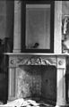 Schouw achterkamer - Sloten - 20201228 - RCE.jpg 772 × 1,200; 166 KB
-
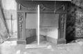
 Schouw opkamer achterhuis - Sloten - 20201229 - RCE.jpg 784 × 1,200; 176 KB
-
 Schouw opkamer achterhuis - Sloten - 20201230 - RCE.jpg 1,200 × 779; 128 KB
-
 Schouw voorkamer - Sloten - 20201231 - RCE.jpg 1,200 × 782; 164 KB
-
 Sloten Friesland imp 079.JPG 3,264 × 2,448; 2.31 MB
-
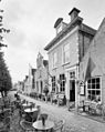
 Sloten Friesland Voorstreek 116.JPG 2,448 × 3,264; 2 MB
-
 Voordeur - Sloten - 20201222 - RCE.jpg 785 × 1,200; 152 KB
-
 Voorgevel (top) - Sloten - 20201223 - RCE.jpg 1,200 × 790; 168 KB
-
 Voorgevels - Sloten - 20201218 - RCE.jpg 802 × 1,200; 200 KB
-
 Voormalige voordeur - Sloten - 20201226 - RCE.jpg 781 × 1,200; 156 KB
-
 Voormalige voordeur detail - Sloten - 20201224 - RCE.jpg 1,200 × 785; 159 KB
-
 Voormalige voordeur, detail - Sloten - 20201227 - RCE.jpg 1,200 × 779; 182 KB
-
 Voorstreek117 Sloten.jpg 2,736 × 3,648; 996 KB
.jpg)
.jpg)


_-_Sloten_-_20201223_-_RCE.jpg)


