Category:Voorstraat 6, Ameide
Jump to navigation
Jump to search
| Object location | | View all coordinates using: OpenStreetMap |
|---|
house in Zederik, Netherlands  | |||||
| Upload media | |||||
| Instance of | |||||
|---|---|---|---|---|---|
| Location | Ameide, South Holland, Netherlands | ||||
| Street address |
| ||||
| Located on street | |||||
| Heritage designation |
| ||||
 | |||||
|
This is a category about rijksmonument number 7594
|
| Address |
|
Media in category "Voorstraat 6, Ameide"
The following 17 files are in this category, out of 17 total.
-
 Ameide RM Voorstraat 6.jpg 2,884 × 3,962; 4.13 MB
-
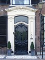 Door.Voorstraat.6.Ameide.jpg 1,506 × 2,007; 861 KB
-
 Exterieur OVERZICHT VOORGEVELS - Ameide - 20276751 - RCE.jpg 946 × 1,200; 272 KB
-
 Exterieur OVERZICHT VOORGEVELS - Ameide - 20276752 - RCE.jpg 1,198 × 1,200; 357 KB
-
 Exterieur VOORGEVEL, VOORDEUR - Ameide - 20276753 - RCE.jpg 1,200 × 1,190; 325 KB
-
 Gevel - Ameide - 20008373 - RCE.jpg 813 × 1,200; 230 KB
-
 Gevels - Ameide - 20008368 - RCE.jpg 1,200 × 801; 178 KB
-
 Gevels - Ameide - 20008372 - RCE.jpg 1,200 × 809; 216 KB
-
 INTERIEUR, EERSTE VERDIEPING, VOORKAMER, SCHOUW - Ameide - 20273714 - RCE.jpg 1,195 × 1,200; 201 KB
-
 INTERIEUR, GANG, TRAPOPGANG - Ameide - 20273711 - RCE.jpg 1,190 × 1,200; 248 KB
-
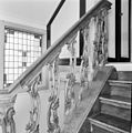 INTERIEUR, TRAP, LEUNING - Ameide - 20273713 - RCE.jpg 1,193 × 1,200; 280 KB
-
 INTERIEUR, TRAPOPGANG - Ameide - 20273712 - RCE.jpg 1,200 × 1,200; 284 KB
-
 Overzicht - Ameide - 20008363 - RCE.jpg 828 × 1,200; 191 KB
-
 Overzicht - Ameide - 20008370 - RCE.jpg 1,196 × 1,200; 270 KB
-
 Voorstraat.6.Ameide.jpg 1,357 × 1,807; 487 KB
-
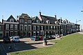 Woonhuis - Voorstraat 6-10.jpg 800 × 534; 270 KB
-
 Woonhuis - Voorstraat 6.jpg 534 × 800; 290 KB


