Category:Voorschoterweg 52, Valkenburg
Jump to navigation
Jump to search
| Object location | | View all coordinates using: OpenStreetMap |
|---|
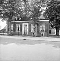
farmhouse in Katwijk, Netherlands  | |||||
| Upload media | |||||
| Instance of | |||||
|---|---|---|---|---|---|
| Location | Valkenburg, Valkenburg | ||||
| Street address |
| ||||
| Located on street |
| ||||
| Heritage designation |
| ||||
 | |||||
|
This is a category about rijksmonument number 42169
|
| Address |
|
Media in category "Voorschoterweg 52, Valkenburg"
The following 9 files are in this category, out of 9 total.
-
 Detail kozijn - Valkenburg - 20238437 - RCE.jpg 1,188 × 1,200; 269 KB
-
 Linker zijgevel stal - Valkenburg - 20238438 - RCE.jpg 1,190 × 1,200; 338 KB
-
 Linker zijgevel stal - Valkenburg - 20238439 - RCE.jpg 1,188 × 1,200; 325 KB
-
 Linker zijgevel woonhuis - Valkenburg - 20238434 - RCE.jpg 1,186 × 1,200; 443 KB
-
 Rechter zijgevel - Valkenburg - 20238436 - RCE.jpg 1,192 × 1,200; 393 KB
-
 Rechter zijgevel woonhuis - Valkenburg - 20238435 - RCE.jpg 1,185 × 1,200; 362 KB
-
 Schuur - Valkenburg - 20238440 - RCE.jpg 1,195 × 1,200; 299 KB
-
 Voorgevel - Valkenburg - 20238433 - RCE.jpg 1,183 × 1,200; 339 KB
-
 Voorschoterweg 52.JPG 2,592 × 1,944; 970 KB


