Category:Voormalige Maria Hemelvaartkerk (Nispen)
Jump to navigation
Jump to search
| Camera location | | View all coordinates using: OpenStreetMap |
|---|
Nederlands: Nispen, Kerkplein - Maria Hemelvaart (1618 - 1944) - De kerk is gesloopt in 1930 - de toren is in 1944 verwoest.
Media in category "Voormalige Maria Hemelvaartkerk (Nispen)"
The following 4 files are in this category, out of 4 total.
-
 Interieur, kerkorgel en tribune - Nispen - 20168409 - RCE.jpg 886 × 1,200; 205 KB
-
 Interieur, orgel - Nispen - 20168408 - RCE.jpg 1,200 × 897; 225 KB
-

-
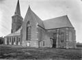 Zicht op de voormalige kerk vanuit het zuid-oosten - Nispen - 20168407 - RCE.jpg 1,200 × 883; 264 KB


