<nowiki>Kategori:Kaliforniya'da volkanizma; Category:Volcanism of California; رده:آتشفشانخیزی کالیفرنیا; വര്ഗ്ഗം: കാലിഫോർണിയയിലെ അഗ്നിപർവ്വതം; تصنيف:بركانية كاليفورنيا; categoría de Wikimedia; kategori Wikimedia; Wikimedia category; د ويکيمېډيا وېشنيزه; Vikimedya kategorisi; ویکیمیڈیا زمرہ; kategória projektov Wikimedia; категорія проєкту Вікімедіа; 维基媒体分类; Wikimedia-Kategorie; ৱিকিমিডিয়াৰ শ্ৰেণী; Викимедиина категорија; kategorija na Wikimediji; विकिपीडिया:श्रेणी; page de catégorie d'un projet Wikimedia; kategorija na Wikimediji; विकिपीडिया वर्ग; категорија на Викимедији; Wikimedia-Kategorie; Wikimedia-kategori; kategori Wikimédia; تصنيف ويكيميديا; pajenn rummata eus Wikimedia; Wikimedia:ကဏ္ဍခွဲခြင်း; 維基媒體分類; Wikimedia категориясы; categoría de Wikimedia; Wikimedia-Kategorie; Викимедиа категорияһы; tudalen categori Wikimedia; kategori e Wikimedias; ردهٔ ویکیمدیا; 维基媒体项目分类; Wikimedia-kategory; ვიკიპედია:კატეგორიზაცია; ウィキメディアのカテゴリ; categoria Wikimedia; تصنيف بتاع ويكيميديا; විකිමීඩියා ප්රභේද පිටුව; categoria Vicimediorum; Vikipidiya:Shopni; Wikimedia-luokka; Wikimedia-categorie; gurühi Vikimedia; катэгорыя ў праекце Вікімэдыя; Викимедиа проектындагы төркем; catigurìa di nu pruggettu Wikimedia; หน้าหมวดหมู่วิกิมีเดีย; Wikimedia:Kategorija; Wikimedia-Kategorie; উইকিমিডিয়া থাক; Уикимедия категория; categorie în cadrul unui proiect Wikimedia; categurìa 'e nu pruggette Wikimedia; Wikimedia-kategori; kawan Wikimèdia; 維基媒體專案分類; 위키미디어 분류; Wikimedia-bólkur; kategorio en Vikimedio; kategori Wikimedia; categoría de Wikimedia; উইকিমিডিয়া বিষয়শ্রেণী; kategori Wikimedia; 维基媒体分类; kategorija w projektach Wikimedije; thể loại Wikimedia; Wikimedia projekta kategorija; kategoria ti Wikimedia; categoria de um projeto da Wikimedia; Wikimedia category; категорияд Ангилал; Wikimedia-kategori; kategori Wikimedia; پۆلی ویکیمیدیا; Wikimedia category; Vikimédia ñemohenda; Wikimédia-kategória; વિકિપીડિયા શ્રેણી; Wikimediako kategoria; категория в проекте Викимедиа; Wikimedia-Kategorie; Kategoriya ning Wikimedia; Wikimedia-kategorie; Wîkîmediya:Kategorî; विकिमिडिया श्रेणी; Wikimedia-Kategorie; 维基媒体项目分类; קטגוריה בוויקיפדיה; Викимедиа проектындагы төркем; 維基媒體分類; विकिमिडिया श्रेणी; categoria de Wikimedia; Wikimedia-kategoriija; гурӯҳ дар лоиҳаи Викимедиа; Wikimedia-categorie; Wikimedia category; Wikimedia-categorie; categoria di un progetto Wikimedia; kategoria w projekcie Wikimedia; 维基媒体分类; Wikimedia:Klassys; Wikimedia kategooria; Wikimedia-kategori; 維基媒體分類; Վիքիմեդիայի նախագծի կատեգորիա; kategorya ng Wikimedia; ẹ̀ka Wikimedia; катэгорыя ў праекце Вікімедыя; categoria de um projeto da Wikimedia; гурӯҳи Викимедиа; kategorie na projektech Wikimedia; tumbung Wikimedia; Wikimedia-Kategorie; kategorija Wikimedie; Wikimedia proyektındağı törkem; Wikimedia-Kategorie; Wikimedia-kategorie; kategori Wikimedia; jamii ya Wikimedia; വിക്കിമീഡിയ വർഗ്ഗം; 維基媒體分類; kategori Wikimedia; Viciméid catagóir; زمرو:وڪيپيڊيا زمرا بندي; விக்கிமீடியப் பகுப்பு; categoría de Wikimedia; Wikimedia:Ronnaghys; κατηγορία εγχειρημάτων Wikimedia; विकिमीडिया श्रेणी</nowiki>
Category:Volcanism of California Wikimedia category |
| Upload media |
|
| Instance of | |
|---|
|
 |
Subcategories
This category has the following 48 subcategories, out of 48 total.

 249 of 'Volcanoes of North America, etc' (11297305805).jpg 1,447 × 867; 257 KB
 Adobe Hills - basaltic outcrop along Dobie Meadows Rd in Mono County, California.JPG 3,456 × 2,592; 4.32 MB
 Bulletin of the Geological Society of America (1903) (20449641775).jpg 3,120 × 2,292; 2.01 MB
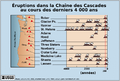 Cascade eruptions in the last 4000 years-fr.png 767 × 515; 71 KB
 Cascade Volcanic Arc.jpg 461 × 686; 84 KB
 Geological Cross Section of Table Mountain, Tuolumne County, California Meters.jpg 3,152 × 2,256; 1.47 MB
 Geological Cross Section of Table Mountain, Tuolumne County, California.png 3,152 × 2,261; 613 KB
 Geothermal areas in Lassen area.gif 632 × 437; 54 KB
 Glass-mountain.jpg 1,024 × 768; 122 KB
 Mount Shasta (15356083710).jpg 864 × 576; 327 KB
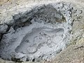 MudPot 8334.jpg 1,600 × 1,200; 616 KB
 Orbicular Rhyolite.JPG 2,048 × 1,536; 783 KB
 Pumice roadcut on CA 178 near Shoshone, California.JPG 3,712 × 2,088; 3.83 MB
 Split cinder cone with Shoreline Butte in background.JPG 1,589 × 517; 191 KB
 Split Cinder Cone.jpg 236 × 148; 16 KB
 VolcanicBombMojaveDesert.JPG 3,617 × 2,628; 8.4 MB
 VolcanicLegacyScenicByway CaliforniaSection.gif 364 × 400; 66 KB
.jpg)

_(20449641775).jpg)


.jpg)


