Category:Vismarkt 4, Zaltbommel
Jump to navigation
Jump to search
| Object location | | View all coordinates using: OpenStreetMap |
|---|
building in Zaltbommel, Netherlands  | |||||
| Upload media | |||||
| Instance of | |||||
|---|---|---|---|---|---|
| Location | Zaltbommel, Gelderland, Netherlands | ||||
| Street address |
| ||||
| Located on street | |||||
| Heritage designation |
| ||||
 | |||||
|
This is a category about rijksmonument number 40266
|
| Address |
|
Media in category "Vismarkt 4, Zaltbommel"
The following 5 files are in this category, out of 5 total.
-
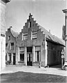 2, Vismarkt - Zaltbommel - 20220537 - RCE.jpg 969 × 1,200; 219 KB
-
 De Vismarkt in Zaltbommel..jpg 4,770 × 3,177; 1.32 MB
-
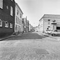 Overzicht Vismarkt en Koningstraat vanaf de Kerkstraat - Zaltbommel - 20219597 - RCE.jpg 1,195 × 1,200; 317 KB
-
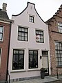 Vismarkt 4.jpg 3,000 × 4,000; 828 KB
-
 Vismarkt 8-6-4, voorgevels - Zaltbommel - 20220538 - RCE.jpg 1,200 × 800; 188 KB


