Category:Virginia State Route 33
Jump to navigation
Jump to search
 | number: | (thirty-three) |
|---|---|---|
| State highways in Virginia: | 13 · 14 · 16 · 18 · 20 · 22 · 24 · 26 · 27 · 28 · 30 · 31 · 32 · 33 · 34 · 35 · 36 · 37 · 38 · 39 · 40 · 41 · 42 · 43 · 45 · 46 · 47 · 48 · 49 · 51 · 53 |
State highway in eastern Virginia, US _at_Virginia_State_Route_14_(The_Trail)_in_Shacklefords,_King_and_Queen_County,_Virginia.jpg)  | |||||
| Upload media | |||||
| Instance of | |||||
|---|---|---|---|---|---|
| Location | Virginia | ||||
| Transport network | |||||
| Owned by | |||||
| Maintained by | |||||
| Inception |
| ||||
| Length |
| ||||
| |||||
English: Media related to Virginia State Route 33
Content within this category should be restricted to media related to the actual roadway. For media related to locations adjacent to the roadway, please use "Locations along Virginia State Route 33"
Subcategories
This category has only the following subcategory.
Media in category "Virginia State Route 33"
The following 17 files are in this category, out of 17 total.
-

-

-
-
 Chestygravemarker.jpg 1,600 × 1,200; 358 KB
-
 Looking down to Deltaville (11595438013).jpg 5,184 × 3,456; 7.64 MB
-
 Stingray Point, 33 looking east to terminus.jpg 6,016 × 4,000; 6.99 MB
-
 Stingray Point, 33 looking west from terminus.jpg 6,016 × 4,000; 6.35 MB
-
 Tangier, VA (26951871551).jpg 5,184 × 3,456; 6.3 MB
-
 Tangier, VA (27020130555).jpg 5,184 × 3,456; 5.68 MB
-
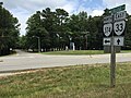
 US17nRoad-VA33eSplit-VA945Fsigns (32437673550).jpg 2,400 × 1,600; 1.62 MB
-
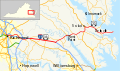 VA 33 map.svg 1,205 × 709; 2.12 MB
-
 VA198wRoadEnd-US17nsVA33ew (32004032583).jpg 2,400 × 1,600; 1.65 MB
-
 VA30eRoad-VA33ewVA1129signs (32004112333).jpg 2,400 × 1,600; 1.89 MB
-
 VA30eVA33eRoad-PamunkeyRiverBridge-WestPoint (32695122471).jpg 2,400 × 1,600; 1.15 MB
-
 Virginia 33 (1924).svg 1,100 × 1,200; 109 KB
-
 Virginia 33.svg 600 × 600; 5 KB
-
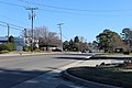
 West Point VA33.jpg 5,184 × 3,456; 6.68 MB
_at_U.S._Route_17_(Tidewater_Trail)_in_Saluda,_Middlesex_County,_Virginia.jpg)
_at_Virginia_State_Route_33_(Lewis_B_Puller_Highway)_at_the_Rappahannock_Community_College_in_Glenns,_Gloucester_County,_Virginia.jpg)

.jpg)


.jpg)
.jpg)
.jpg)
.jpg)
.jpg)
.jpg)
.svg)
