Category:Villa Streichenberg
Jump to navigation
Jump to search
| Object location | | View all coordinates using: OpenStreetMap |
|---|
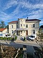
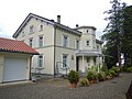
residential building in Lutzenberg in the canton of Appenzell Ausserrhoden, Switzerland  | |||||
| Upload media | |||||
| Instance of | |||||
|---|---|---|---|---|---|
| Part of | |||||
| Location |
| ||||
| Street address |
| ||||
| Heritage designation | |||||
 | |||||
Media in category "Villa Streichenberg"
The following 3 files are in this category, out of 3 total.
-
 Dorfhalde 146.jpg 3,000 × 2,492; 5.35 MB
-
 Dorfhalde146.jpg 3,000 × 4,000; 3.92 MB
-
 Lutzenberg Dorfhalde 146.jpg 4,608 × 3,456; 2.5 MB

