Category:Views of Roussolakkos from Petsophas
Jump to navigation
Jump to search
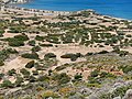
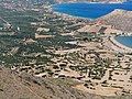
English: Petsophas is the elevation to the south sloping down to Cape Plaka. From there the Kastri promontory is visible to the north, Chiona beach to the east, and the site of Roussolakkos in the entire foregound.
Media in category "Views of Roussolakkos from Petsophas"
The following 12 files are in this category, out of 12 total.
-
 Roussolakkos Argyrakis Mavrokoukoulakis Papadakis 01.jpg 4,715 × 3,536; 11.84 MB
-
 Roussolakkos Argyrakis Mavrokoukoulakis Papadakis 02.jpg 4,864 × 3,647; 14.79 MB
-
 Roussolakkos Argyrakis Mavrokoukoulakis Papadakis 03.jpg 4,833 × 3,624; 13.4 MB
-
 Roussolakkos Argyrakis Mavrokoukoulakis Papadakis 04.jpg 4,864 × 3,647; 15.19 MB
-
 Roussolakkos Argyrakis Mavrokoukoulakis Papadakis 05.jpg 4,715 × 3,536; 12.91 MB
-
 Roussolakkos Ebene 01.jpg 4,734 × 3,551; 10.72 MB
-
 Roussolakkos Ebene 02.jpg 4,864 × 3,647; 14.1 MB
-
 Roussolakkos Ebene 03.jpg 4,854 × 3,636; 12.81 MB
-
 Roussolakkos Ebene 04.jpg 4,864 × 3,647; 14.88 MB
-
 Roussolakkos Ebene 05.jpg 4,626 × 3,469; 12.34 MB
-
 Roussolakkos Ebene 06.jpg 4,715 × 3,536; 10.37 MB
-
 Roussolakkos Ebene 07.jpg 4,756 × 3,562; 12.91 MB


