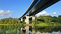
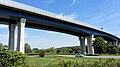
Category:Viaduc de Schengen
Jump to navigation
Jump to search
| Object location | | View all coordinates using: OpenStreetMap |
|---|
 | |||||
| Upload media | |||||
| Instance of | |||||
|---|---|---|---|---|---|
| Part of | |||||
| Location | |||||
| Crosses | |||||
| Carries | |||||
| Inception |
| ||||
| Length |
| ||||
 | |||||
Media in category "Viaduc de Schengen"
The following 8 files are in this category, out of 8 total.
-

-
 ORTELIUS in SCHENGEN, Luxembourg.jpg 2,560 × 1,440; 1.24 MB
-
 SCHENGEN MOTORWAY BRIDGE.jpg 2,515 × 1,415; 905 KB
-
 Viaduc vu Schengen 2006 2.jpg 1,743 × 1,170; 809 KB
-
 Viaduc vu Schengen 2006.jpg 2,048 × 1,360; 717 KB
-
 Viadukto en Ŝengeno.jpg 4,160 × 2,336; 3.29 MB
-
 View from Remerschen to Perl 01.jpg 3,500 × 2,483; 5.5 MB
-
 Vue Schengener Viaduc-101.jpg 4,521 × 3,017; 8.48 MB


Categories:
- Perl (Mosel)
- Buildings in Schengen
- Moselle River in Schengen
- Moselle River in Landkreis Merzig-Wadern
- Bridges over Moselle River in Luxembourg
- Road bridges in Saarland
- Highway bridges in Luxembourg
- Iron beam bridges in Luxembourg
- Iron beam highway bridges in Germany
- E29 (Luxembourg)
- Bundesautobahn 8 bridges
- A13 (Luxembourg)
- Cantilever bridges in Luxembourg
- Germany-Luxembourg border crossings
- Bridges with 8 spans