Category:Vhembe District Municipality
Jump to navigation
Jump to search
district municipality in Limpopo, South Africa | |||||
| Upload media | |||||
| Instance of |
| ||||
|---|---|---|---|---|---|
| Location | Limpopo, Transvaal region | ||||
| Capital | |||||
| Inception |
| ||||
| Population |
| ||||
| Area |
| ||||
| Elevation above sea level |
| ||||
| official website | |||||
 | |||||
Afrikaans: Die Vhembe-distriksmunisipaliteit is een van 5 distriksmunisipaliteite in Limpopo. Die setel van die munisipaliteit is in Thohoyandou. Die meeste inwoners van die munisipale gebied is Vendasprekend. Die munisipale kode is DC34.
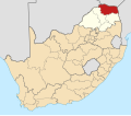
English: Vhembe is one of 5 districts of Limpopo province, South Africa. It is the northernmost district of the country and shares its northern border with Beitbridge district in Matabeleland South, Zimbabwe. Vhembe includes all territories formerly part of the Venda Bantustan, besides districts of the northern and western Gazankulu Bantustan, hence its ethnic diversity. The seat of Vhembe is Thohoyandou, the former capital of the former Venda Bantustan. According to the 2001 census, 800,000 of Vhembe residents speak Venda as their mother language, 400,000 speak Tsonga and 27,000 speak Northern Sotho. The district code is DC34.
Subcategories
This category has the following 8 subcategories, out of 8 total.
M
T
V
Media in category "Vhembe District Municipality"
The following 13 files are in this category, out of 13 total.
-
DC34 locator.svg 1,000 × 602; 170 KB
-
Lwamondo Mountaion - panoramio.jpg 1,849 × 1,025; 247 KB
-
Lwamondo Peak- Sunset - panoramio.jpg 2,592 × 1,944; 1.1 MB
-
Lwamondo Tshivhale- At dusk, the fires start to prepare dinner - panoramio.jpg 2,592 × 1,944; 1.27 MB
-
Lwamondo Tshivhale- Roof being thatched - panoramio.jpg 2,592 × 1,944; 2.54 MB
-
Map No. 33 of Schedule 2 to Notice 1998 of 2005.png 2,800 × 1,950; 4 MB
-
Map of Limpopo with Vhembe highlighted (2006).svg 925 × 621; 351 KB
-
Map of Limpopo with Vhembe highlighted (2011).svg 925 × 621; 286 KB
-
Map of Limpopo with Vhembe highlighted (2016).svg 925 × 621; 413 KB
-
Map of South Africa with Vhembe highlighted (2011).svg 809 × 709; 482 KB
-
Map of South Africa with Vhembe highlighted (2016).svg 809 × 709; 697 KB
-
Newly Built house - panoramio.jpg 4,404 × 2,120; 880 KB
-
South Africa Districts showing Vhembe.png 1,141 × 828; 31 KB


