Category:Vegetation maps of national parks in the United States
Jump to navigation
Jump to search
Subcategories
This category has the following 2 subcategories, out of 2 total.
Media in category "Vegetation maps of national parks in the United States"
The following 18 files are in this category, out of 18 total.
-
 NPS arches-national-park-vegetation-map.jpg 2,008 × 2,520; 818 KB
-
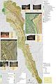
 NPS big-bend-vegetation-map.jpg 1,088 × 1,264; 280 KB
-
 NPS canyonlands-vegetation-map.jpg 3,860 × 4,829; 3.61 MB
-
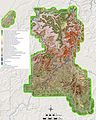
 NPS capitol-reef-vegetation-map.jpg 5,097 × 7,590; 6.54 MB
-
 NPS cuyahoga-valley-vegetation-map.gif 3,977 × 4,777; 1.79 MB
-
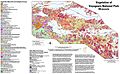
 NPS glacier-national-park-vegetation-map.jpg 5,928 × 7,512; 8.58 MB
-
 NPS glacier-bay-vegetation-map.jpg 6,038 × 3,942; 3.8 MB
-
 NPS grand-teton-vegetation-map.gif 4,162 × 5,766; 3.67 MB
-
 NPS great-basin-vegetation-map.jpg 4,902 × 4,514; 5.03 MB
-
 NPS joshua-tree-vegetation-map.gif 4,883 × 2,636; 1.15 MB
-
 NPS lake-clark-vegetation-map.jpg 5,252 × 6,516; 9.39 MB
-
 NPS mesa-verde-vegetation-map.jpg 1,868 × 2,397; 708 KB
-
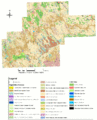 NPS badlands-vegetation-map.gif 4,000 × 4,960; 2.36 MB
-
 NPS petrified-forest-vegetation-map.gif 2,016 × 2,820; 791 KB
-
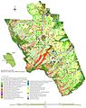
 NPS voyageurs-vegetation-map.jpg 3,949 × 2,420; 2.12 MB
-
 NPS wind-cave-vegetation-map.gif 3,329 × 2,024; 1.51 MB
-
 Yose veg zonesm.jpg 620 × 749; 88 KB
-
 NPS zion-vegetation-map.jpg 4,480 × 4,172; 5 MB


