Category:Vaynor
Jump to navigation
Jump to search
village in Merthyr Tydfil Country Borough, UK  Eglwys Sant Gwynno, y Faenor  | |||||
| Upload media | |||||
| Pronunciation audio | |||||
|---|---|---|---|---|---|
| Instance of | |||||
| Location | Merthyr Tydfil, Wales | ||||
| Population |
| ||||
| Area |
| ||||
 | |||||

Cymraeg: Pentref a chymuned ym mwrdeisdref sirol Merthyr Tudful yn ne Cymru yw y Faenor (Saesneg: Vaynor). Saif i'r gogledd o dref Merthyr, ac mae'r gymuned hefyd yn cynnwys treflan Trefechan. Roedd poblogaeth y gymuned yn 2001 yn 3,465.
English: Vaynor (or in Welsh: Faenor, meaning The Manor) is a village and community in the Merthyr Tydfil county borough in Wales, United Kingdom.
Subcategories
This category has the following 8 subcategories, out of 8 total.
Media in category "Vaynor"
The following 200 files are in this category, out of 383 total.
(previous page) (next page)-
 16 miles to Brecon - geograph.org.uk - 6555195.jpg 2,102 × 2,803; 2.9 MB
-
 A stream joins the Taf Fechan - geograph.org.uk - 3718369.jpg 640 × 480; 143 KB
-
 A view across Pontiscill Reservoir - geograph.org.uk - 3168295.jpg 640 × 472; 61 KB
-

-
 A weak bridge near Pontsticill - geograph.org.uk - 3084717.jpg 640 × 480; 184 KB
-
 A4054 junction from A470 - geograph.org.uk - 3131314.jpg 640 × 389; 83 KB
-
 A465 nearing the A470 roundabout - geograph.org.uk - 3791044.jpg 640 × 480; 47 KB
-
 A465 roundabout ahead - geograph.org.uk - 3131307.jpg 640 × 457; 55 KB
-
 A470 at Brecon Beacons National Park boundary - geograph.org.uk - 5896111.jpg 1,024 × 820; 177 KB
-
 A470 at Llwyn-onn - geograph.org.uk - 5896142.jpg 1,024 × 783; 176 KB
-
 A470 at Llwyn-Onn village boundary - geograph.org.uk - 5896137.jpg 1,024 × 750; 153 KB
-
 A470 at signs for Llwyn-onn - geograph.org.uk - 3131333.jpg 640 × 324; 56 KB
-
 A470 below Darren Fawr - geograph.org.uk - 5896123.jpg 1,024 × 710; 144 KB
-
 A470 Brecon to Merthyr road - geograph.org.uk - 6421348.jpg 4,032 × 3,024; 7.22 MB
-
 A470 distances from Cefn-coed-y-cymmer - geograph.org.uk - 4032789.jpg 800 × 560; 117 KB
-
 A470 Merthyr Tydfil by-pass - geograph.org.uk - 1993543.jpg 640 × 480; 74 KB
-
 A470 near Pont Aber Car - geograph.org.uk - 3131349.jpg 640 × 446; 91 KB
-
 Aberglais Inn - geograph.org.uk - 4865850.jpg 2,448 × 2,448; 1.55 MB
-

-
 Accommodation in Cwm Llysiog - geograph.org.uk - 4750103.jpg 640 × 480; 95 KB
-
 Afon Taf Fechan at Pont Sarn - geograph.org.uk - 3474537.jpg 640 × 480; 177 KB
-
 And another fence post - geograph.org.uk - 6422523.jpg 1,536 × 2,048; 1.83 MB
-
 Angler at Pontsticill reservoir - geograph.org.uk - 5963093.jpg 1,499 × 1,124; 448 KB
-
 Another fence post - geograph.org.uk - 6422385.jpg 1,536 × 2,048; 1.39 MB
-
 Autumn scene in Merthyr Tydfil - geograph.org.uk - 3718663.jpg 640 × 480; 102 KB
-

-
 Bank Terrace, Cefn-coed-y-cymmer - geograph.org.uk - 4050624.jpg 800 × 563; 121 KB
-
 Beacons Park Natural Burial Ground - geograph.org.uk - 6296198.jpg 4,000 × 3,000; 2.92 MB
-
 Beacons Park Natural Burial Ground - geograph.org.uk - 6296200.jpg 4,000 × 3,000; 2.89 MB
-
 Beside the Taff Trail near Pontsarn - geograph.org.uk - 1998347.jpg 640 × 480; 114 KB
-
 Bilingual sign - geograph.org.uk - 6583280.jpg 1,536 × 2,048; 1.01 MB
-
 Blue Pool - or White Pool^ - geograph.org.uk - 4767235.jpg 1,280 × 960; 352 KB
-
 Boundary stone on Twyn y Groes - geograph.org.uk - 4768722.jpg 640 × 480; 93 KB
-
 Brecon Beacons - geograph.org.uk - 6583259.jpg 2,517 × 1,888; 1.34 MB
-

-
 Brecon mountain railway - geograph.org.uk - 2056019.jpg 640 × 480; 95 KB
-
 Brecon Mountain Railway - geograph.org.uk - 6585129.jpg 2,638 × 3,517; 4.87 MB
-
 Brecon Mountain Railway - Pontsticill - geograph.org.uk - 6472756.jpg 1,546 × 909; 248 KB
-

-

-
 Brecon Mountain Railway - Steam Museum - geograph.org.uk - 4161386.jpg 640 × 427; 130 KB
-
 Brecon Mountain Railway at Pontsticill - geograph.org.uk - 3390266.jpg 4,000 × 3,000; 3.89 MB
-

-
 Brecon Mountain Railway at Pontsticill - geograph.org.uk - 6206488.jpg 5,066 × 2,850; 4.86 MB
-

-
 Brecon Mountain Railway Museum - geograph.org.uk - 4602007.jpg 640 × 480; 90 KB
-
 Brecon Mountain Railway near Pontsticill - geograph.org.uk - 3390257.jpg 4,000 × 3,000; 4.14 MB
-

-

-

-
 Brecon Mountain Railway train entering Pontsticill station - geograph.org.uk - 3119317.jpg 1,629 × 1,117; 1.14 MB
-

-
 Brecon steam railway - geograph.org.uk - 2056008.jpg 480 × 640; 100 KB
-
 Bridge over Taff Trail at Pontsarn - geograph.org.uk - 1998338.jpg 640 × 480; 130 KB
-

-

-
 Bridge over the Taf Fawr - geograph.org.uk - 2361742.jpg 2,816 × 2,112; 2.28 MB
-
 Bridge over the Taf Fechan - geograph.org.uk - 6020420.jpg 2,048 × 1,536; 1.32 MB
-
 Bridge over the Taff Trail at Pont Sarn - geograph.org.uk - 3718639.jpg 640 × 480; 110 KB
-
 Bryntaf, Cefn-coed-y-cymmer - geograph.org.uk - 4050769.jpg 800 × 621; 129 KB
-
 Cae Burdydd motte near Vaynor (geograph 3718583).jpg 640 × 480; 103 KB
-

-
 Car park above Pont Sarn - geograph.org.uk - 3718413.jpg 640 × 480; 122 KB
-
 Carmel Chapel, Cefn-coed-y-cymmer - geograph.org.uk - 5494079.jpg 4,608 × 3,456; 3.56 MB
-
-
 Carn-ddu - geograph.org.uk - 5864126.jpg 1,024 × 483; 142 KB
-
 Castle Inn, Cefn-coed-y-cymmer - geograph.org.uk - 5494071.jpg 4,608 × 3,456; 3.72 MB
-
 Cefn Car - geograph.org.uk - 6423550.jpg 4,032 × 3,024; 6.96 MB
-
 Cefn Cil-Sanws - geograph.org.uk - 5700746.jpg 640 × 480; 88 KB
-
 Cefn Cil-sanws - geograph.org.uk - 6555178.jpg 2,048 × 1,536; 998 KB
-
 Cefn Coed Club, Cefn-coed-y-cymmer - geograph.org.uk - 4050756.jpg 800 × 622; 121 KB
-

-
 Cefn Coed RFC, Cefn-coed-y-cymmer - geograph.org.uk - 4050399.jpg 800 × 649; 137 KB
-
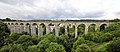 Cefn Coed Viaduct near Merthyr Tydfil - geograph.org.uk - 2023854.jpg 4,291 × 1,860; 2.99 MB
-
 Cefn Coed viaduct, Merthyr - geograph.org.uk - 1998367.jpg 640 × 480; 84 KB
-
 Cefn Coed Viaduct, Merthyr Tydfil - geograph.org.uk - 3420175.jpg 640 × 480; 101 KB
-
 Cefn Coed Viaduct, Merthyr Tydfil - geograph.org.uk - 3423907.jpg 640 × 480; 123 KB
-

-
 Cefn Pantry, Cefn-coed-y-cymmer - geograph.org.uk - 4029719.jpg 800 × 588; 107 KB
-
 Cefn Ynys Fawr - geograph.org.uk - 6422358.jpg 1,536 × 2,048; 1.48 MB
-

-
 Cefn-y-Coed-y-Cymmer, High Street, 1990 - geograph.org.uk - 4299644.jpg 2,278 × 1,424; 4.07 MB
-
 Christmas tree at Pontsticill Station - geograph.org.uk - 3768097.jpg 640 × 480; 127 KB
-
 Church Hall in Cefn-coed-y-cymmer - geograph.org.uk - 4050565.jpg 800 × 544; 99 KB
-
 Climbing Cefn yr Ystrad from Pontsticill - geograph.org.uk - 2957145.jpg 2,592 × 1,944; 2.32 MB
-
 Cloth Hall Lane, Cefn-coed-y-cymmer - geograph.org.uk - 4032707.jpg 800 × 505; 126 KB
-
 Coal supplies at Pontsticill on the Brecon Mountain Railway - geograph.org.uk - 2542698.jpg 2,816 × 2,112; 2.11 MB
-

-

-

-
 County boundary on A470 - geograph.org.uk - 1993608.jpg 640 × 480; 81 KB
-
 Crossing Waun Wen towards Gwaun y Pynt - geograph.org.uk - 6422879.jpg 2,048 × 1,536; 1.25 MB
-
 Curve on the path beside the Taf Fechan - geograph.org.uk - 3718383.jpg 640 × 480; 165 KB
-
 Cwm and Pontsticill - geograph.org.uk - 4050791.jpg 640 × 427; 115 KB
-
 Cwm Llysiog - geograph.org.uk - 4750091.jpg 640 × 480; 86 KB
-
 Cwm Llysiog - geograph.org.uk - 6422331.jpg 3,024 × 4,032; 6.02 MB
-
 Cwm Taf Fawr - geograph.org.uk - 6555182.jpg 2,048 × 1,536; 1.04 MB
-
 Cwm Taf Fechan LNR - geograph.org.uk - 491098.jpg 480 × 640; 132 KB
-

-
 Cyfarthfa Leat, Merthyr Tydfil - geograph.org.uk - 3428022.jpg 640 × 480; 172 KB
-

-
 Cymer-confluence - geograph.org.uk - 3894443.jpg 1,024 × 768; 241 KB
-
 Dam and valve tower at Pontsticill - geograph.org.uk - 4037626.jpg 640 × 427; 70 KB
-

-
 Dam at Pontsticill reservoir - geograph.org.uk - 6583262.jpg 2,048 × 1,536; 1 MB
-

-
 Dam of Pontsticill Reservoir - geograph.org.uk - 2644951.jpg 1,500 × 1,125; 1.42 MB
-
 Dan y Graig Farm - geograph.org.uk - 6555171.jpg 2,048 × 1,536; 1.33 MB
-
 Dan-y-deri Lane, Cefn-coed-y-cymmer - geograph.org.uk - 4029513.jpg 759 × 800; 226 KB
-
 Danydarren Quarry - geograph.org.uk - 3294008.jpg 640 × 480; 113 KB
-
 Departure from Pontsticill - geograph.org.uk - 2542701.jpg 2,816 × 2,112; 2.08 MB
-
 Dilapidated limekiln - geograph.org.uk - 3894479.jpg 768 × 1,024; 249 KB
-
 Direction Sign – Signpost - geograph.org.uk - 6578315.jpg 689 × 1,024; 196 KB
-
 Disused railway underpass, Pontsticill - geograph.org.uk - 3168316.jpg 640 × 480; 149 KB
-
 Diverging Tracks - July 2012 - panoramio.jpg 2,812 × 3,654; 5.32 MB
-
 Dol y Coed, Vaynor - geograph.org.uk - 5371298.jpg 2,646 × 2,069; 1,003 KB
-
 Drovers Arms, Cefn Coed - geograph.org.uk - 5466391.jpg 3,264 × 2,448; 2.28 MB
-
 Drovers Arms, Cefn-coed-y-cymmer - geograph.org.uk - 4032886.jpg 800 × 532; 99 KB
-
 Duckboards carrying the path - geograph.org.uk - 3718459.jpg 640 × 480; 156 KB
-

-
 Eastern boundary of Pontsticill - geograph.org.uk - 3168291.jpg 640 × 585; 114 KB
-
-

-

-

-
 Entrance to Garwnant - geograph.org.uk - 3131355.jpg 640 × 480; 94 KB
-

-

-
 Evergreen Fish Bar, Cefn-coed-y-cymmer - geograph.org.uk - 4029509.jpg 800 × 732; 134 KB
-
 Farm near Llwyn-Onn Village - geograph.org.uk - 1993599.jpg 640 × 480; 116 KB
-
 Fedw Farm - geograph.org.uk - 6421357.jpg 4,032 × 3,024; 4.7 MB
-
 Ffrwd Uchaf entrance from A470 - geograph.org.uk - 3131312.jpg 640 × 435; 59 KB
-
 Footpath beneath the Brecon Mountain Railway - geograph.org.uk - 3390276.jpg 4,000 × 3,000; 4.29 MB
-
 Footpath to the hills in Pontsticill - geograph.org.uk - 3390274.jpg 4,000 × 3,000; 4.68 MB
-
 Former railway trackbed in Pontsticill - geograph.org.uk - 3390279.jpg 4,000 × 3,000; 4.01 MB
-
 Former railway trackbed in Pontsticill - geograph.org.uk - 3390282.jpg 4,000 × 3,000; 4.32 MB
-
 From the Brecon Mountain Railway - 27th July 2012 - panoramio.jpg 4,000 × 3,000; 3.39 MB
-
 From the rear carriage - July 2012 - panoramio.jpg 3,000 × 4,000; 4.08 MB
-
 Gated yard - geograph.org.uk - 6555291.jpg 2,048 × 1,536; 1.38 MB
-

-
 Glimpse of Pontsarn Viaduct - geograph.org.uk - 5467768.jpg 3,264 × 2,448; 4.73 MB
-
 HD ink in Cefn-coed-y-cymmer - geograph.org.uk - 4029525.jpg 800 × 702; 146 KB
-
 Heading to Brecon - geograph.org.uk - 4423468.jpg 1,024 × 768; 118 KB
-
 Heads of the Valleys road - geograph.org.uk - 6555210.jpg 2,786 × 3,715; 3.86 MB
-
 Health and Safety Signs - geograph.org.uk - 5371280.jpg 3,264 × 2,448; 4.59 MB
-

-
 Heol Ponsticill - Ponsticill Road - geograph.org.uk - 5505288.jpg 640 × 480; 93 KB
-
 High St, Cefn-coed-y-cymmer - geograph.org.uk - 5494082.jpg 4,608 × 3,456; 3.66 MB
-
 Holford St, Cefn-coed-y-cymmer - geograph.org.uk - 5494099.jpg 4,608 × 3,456; 3.78 MB
-

-
 Holford Street, Cefn-coed-y-cymmer - geograph.org.uk - 4249054.jpg 800 × 800; 174 KB
-

-
 Hy Brasail - geograph.org.uk - 5371294.jpg 3,264 × 2,448; 2.45 MB
-
 Hy Brasail - geograph.org.uk - 6583307.jpg 3,918 × 2,938; 3.62 MB
-
 Hy Brasail near Vaynor - geograph.org.uk - 3718618.jpg 640 × 480; 90 KB
-
 Hy Brasail, Vaynor - geograph.org.uk - 4321150.jpg 2,288 × 1,712; 732 KB
-

-
 Job’s Lane - geograph.org.uk - 6555293.jpg 2,048 × 1,536; 1.08 MB
-
 Lane and river - geograph.org.uk - 6020422.jpg 3,264 × 2,448; 3.89 MB
-
 Layby for the A470 - geograph.org.uk - 3051195.jpg 3,648 × 2,736; 2.97 MB
-
 Lignicolous fungi, Vaynor limestone wood, November 1976 (25385758499).jpg 961 × 1,500; 187 KB
-
 Llwybr Ceffyl y Fedw - Fedw Bridleway - geograph.org.uk - 5214278.jpg 640 × 428; 103 KB
-
 Llwybr Taf - Taff Trail - geograph.org.uk - 4091163.jpg 640 × 480; 110 KB
-
 Llwybr Taf - Taff Trail - geograph.org.uk - 5505116.jpg 640 × 480; 104 KB
-
 Llwybr Taf - Taff Trail - geograph.org.uk - 5505123.jpg 640 × 480; 113 KB
-
 Llwybr y Fedw - Fedw Path - geograph.org.uk - 5700764.jpg 640 × 480; 94 KB
-
 Llwybr y Fedw - Fedw Path - geograph.org.uk - 5700767.jpg 640 × 480; 113 KB
-
 Llwyn-on reservoir - geograph.org.uk - 2361737.jpg 2,112 × 2,816; 2.16 MB
-
 Llwyn-on Reservoir Merthyr Tydfil - panoramio.jpg 4,000 × 3,000; 3.31 MB
-
 Llwyn-onn Reservoir viewed from the dam - geograph.org.uk - 6048671.jpg 800 × 600; 121 KB
-
 Llwynybrain from the Brecon Mountain Railway - geograph.org.uk - 3661367.jpg 1,024 × 683; 834 KB
-
 Loco at Brecon Mountain Railway - geograph.org.uk - 4601994.jpg 640 × 480; 72 KB
-

-
 Lovely view up the Lake - July 2012 - panoramio.jpg 4,000 × 3,000; 2.14 MB
-

-

-
 Mango House, Cefn-coed-y-cymmer - geograph.org.uk - 4029768.jpg 800 × 709; 137 KB
-
 Milestone - Brecon 13 - geograph.org.uk - 4638544.jpg 480 × 640; 136 KB
-
 Milestone - Brecon 15 - geograph.org.uk - 4523687.jpg 480 × 640; 132 KB
-
 Milestone - Brecon 16 - geograph.org.uk - 4523692.jpg 480 × 640; 132 KB
-

-

-
 Moss-covered limestone - geograph.org.uk - 4689667.jpg 5,472 × 3,648; 7.31 MB
-
 Moss-covered tree roots - geograph.org.uk - 6423688.jpg 1,536 × 2,048; 1.3 MB
-
 Nant Ddu Lodge and Fan Fawr - geograph.org.uk - 6422341.jpg 3,024 × 4,032; 5.6 MB
-
 Nant Llysiog - geograph.org.uk - 4750112.jpg 640 × 480; 110 KB
-
 Nant Llysiog - geograph.org.uk - 4766159.jpg 640 × 480; 107 KB
-
 Nant Llysiog - geograph.org.uk - 4766161.jpg 640 × 480; 113 KB
-
 Nant y Grawen - geograph.org.uk - 5700762.jpg 640 × 480; 117 KB
-
 Nant y Wern - geograph.org.uk - 5700759.jpg 640 × 480; 98 KB
-

-

-
 Northern boundary of Pontsticill - geograph.org.uk - 2618051.jpg 640 × 480; 78 KB
-
 Old and new road signs - geograph.org.uk - 3767528.jpg 640 × 640; 100 KB
-
 Old Milestone by the A470 in Taff Vale - geograph.org.uk - 6035680.jpg 720 × 960; 165 KB
-
 Old road from Pontsticill to Penderyn - geograph.org.uk - 6423763.jpg 4,032 × 3,024; 7.98 MB
-

-
-
 On the Taff Trail at Trefechan - geograph.org.uk - 3718646.jpg 640 × 480; 62 KB
-
 Ordnance Survey Cut Mark - geograph.org.uk - 3955959.jpg 480 × 640; 108 KB


.jpg)


.jpg)


