Category:Valid SVG created with ArcGIS
Jump to navigation
Jump to search
Media in category "Valid SVG created with ArcGIS"
The following 29 files are in this category, out of 29 total.
-
 Baneh, Kurdistan Province locator map.svg 1,980 × 1,530; 3.34 MB
-
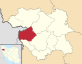
 Bijar, Kurdistan Province locator map.svg 1,980 × 1,530; 3.34 MB
-
 Dehgolan, Kurdistan Province locator map.svg 1,980 × 1,530; 3.34 MB
-
 Diocese of Morombe in Madagascar map.svg 765 × 1,260; 991 KB
-
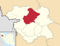 Divandarreh, Kurdistan Province locator map.svg 1,980 × 1,530; 3.34 MB
-
 Ghorveh, Kurdistan Province locator map.svg 1,980 × 1,530; 3.34 MB
-
 Kamyran, Kurdistan Province locator map.svg 1,980 × 1,530; 3.34 MB
-
 Kurdistan Province districts map (blank).svg 1,980 × 1,530; 3.33 MB
-
 Kurdistan Province districts map (with labels).svg 1,980 × 1,530; 3.35 MB
-
 London Underground Northern line extension map.svg 1,175 × 807; 207 KB
-
 Madagascar districts location map.svg 765 × 1,260; 992 KB
-
 Marivan, Kurdistan Province locator map.svg 1,980 × 1,530; 3.34 MB
-
 Sanandaj, Kurdistan Province locator map.svg 1,980 × 1,530; 3.34 MB
-
 Saqqez, Kurdistan Province locator map.svg 1,980 × 1,530; 3.34 MB
-
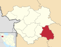
 Sarvabad, Kurdistan Province locator map.svg 1,980 × 1,530; 3.34 MB
-
 Tehran District 10.svg 1,489 × 1,053; 1,003 KB
-
 Tehran District 11.svg 1,489 × 1,053; 1,003 KB
-
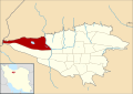
 Tehran District 2.svg 1,489 × 1,053; 1,001 KB
-
 Tehran District 22.svg 1,489 × 1,053; 1.01 MB
-
 Tehran District 3.svg 1,489 × 1,053; 1,003 KB
-
 Tehran District 4.svg 1,489 × 1,053; 1,003 KB
-
 Tehran District 5.svg 1,489 × 1,053; 1,003 KB
-
 Tehran District 6.svg 1,489 × 1,053; 1,003 KB
-
 Tehran District 7.svg 1,489 × 1,053; 1,003 KB
-
 Tehran District 8.svg 1,489 × 1,053; 1,003 KB
-
 Tehran District 9.svg 1,489 × 1,053; 1,003 KB
-
 Tehran district map (blank).svg 1,489 × 1,053; 1,002 KB
-
 Tehran Province location map (with labels).svg 1,980 × 1,035; 324 KB
-
 Zonotrichia albicollis map.svg 709 × 531; 6.73 MB


.svg)


.svg)

.svg)
.svg)