Category:Vaigai River
Jump to navigation
Jump to search
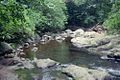
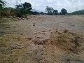
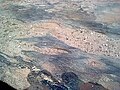
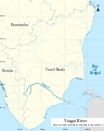
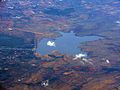
English: The Vaigai is a river in Madurai, Tamil Nadu state of southern India. It originates in the Periyar Plateau of the Western Ghats range, and flows northeast through the Kambam Valley, which lies between the Palni Hills to the north and the Varushanad Hills to the south. The Vattaparai Falls are located on this river. As it rounds the eastern corner of the Varushanad Hills, the river turns southeast, running through the region of Pandya Nadu. Madurai, the largest city in the Pandya Nadu region and its ancient capital, lies on the Vaigai. The river empties into the Palk Strait in Ramanathapuram District.
river in south India  | |||||
| Upload media | |||||
| Instance of | |||||
|---|---|---|---|---|---|
| Location | Tamil Nadu, India | ||||
| Length |
| ||||
 | |||||
Subcategories
This category has the following 2 subcategories, out of 2 total.
V
- Vaigai Dam (15 F)
- Vaigai River in Madurai (13 F)
Media in category "Vaigai River"
The following 27 files are in this category, out of 27 total.
-
 6th day of Thirumangalam Shri Pathrakali Mariamman Vaigasi Festival.jpg 3,887 × 2,448; 376 KB
-
 Map River Vaigai EN.png 1,653 × 1,519; 504 KB
-
 Map River Vaigai TA.png 744 × 681; 148 KB
-
 Monsoon season in Vaigai River.jpg 2,048 × 1,366; 2.17 MB
-
 Monsoon season in Vaigai.jpg 3,000 × 2,001; 3.33 MB
-
 Periyar origin.jpg 500 × 333; 36 KB
-
 River site.JPG 4,320 × 2,432; 3.92 MB
-
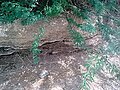 Sand mining 11.jpg 360 × 270; 49 KB
-
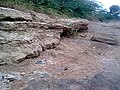 Sand mining 12.jpg 360 × 270; 46 KB
-
 Sand mining 13.jpg 360 × 270; 44 KB
-
 Sand mining 14.jpg 360 × 270; 38 KB
-
 Sand mining 15.jpg 360 × 270; 42 KB
-
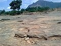 Sand mining at river 1.jpg 360 × 270; 42 KB
-
 Sand mining at river 10.jpg 360 × 270; 43 KB
-
 Sand mining at river 2.jpg 360 × 270; 41 KB
-
 Sand mining at river 3.jpg 360 × 270; 44 KB
-
 Sand mining at river 4.jpg 360 × 270; 42 KB
-
 Sand mining at river 5.jpg 360 × 270; 47 KB
-
 Sand mining at river 6.jpg 360 × 270; 45 KB
-
 Sand mining at river 7.jpg 360 × 270; 49 KB
-
 Sand mining at river 8.jpg 360 × 270; 46 KB
-
 Sand mining at river 9.jpg 360 × 270; 46 KB
-
 SVG Map River Vaigai EN.svg 567 × 709; 343 KB
-
 Vaigai Dam - August 2016.jpg 4,608 × 3,456; 7.98 MB
-
 Vaigai River Railway bridge.jpg 4,096 × 2,304; 2.02 MB
-
 VAIGAI RIVER. BORDER OF SHOLAVANDAN WESTERN SIDE.jpg 5,400 × 3,600; 7.24 MB
-
 Viagai river.jpg 1,280 × 960; 72 KB


