Category:Upplands runinskrifter 768
Jump to navigation
Jump to search
|
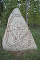
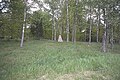
This is a category about an archaeological site or a monument in Sweden, number 10029201680003 in the RAÄ Fornsök database. |
| Object location | | View all coordinates using: OpenStreetMap |
|---|
 | |||||
| Upload media | |||||
| Instance of | |||||
|---|---|---|---|---|---|
| Location | Enköping Municipality, Uppsala County, Sweden | ||||
 | |||||
Media in category "Upplands runinskrifter 768"
The following 8 files are in this category, out of 8 total.
-
 U768 Grop-Norrby - KMB - 16000300033395.jpg 512 × 768; 158 KB
-
 U768 Grop-Norrby - KMB - 16000300033396.jpg 512 × 768; 158 KB
-
 U768 Grop-Norrby - KMB - 16000300033397.jpg 768 × 512; 201 KB
-
 U768 Grop-Norrby - KMB - 16000300033398.jpg 768 × 512; 147 KB
-
 U768 Grop-Norrby - KMB - 16000300033399.jpg 512 × 768; 127 KB
-
 U768 Grop-Norrby - KMB - 16000300033400.jpg 768 × 512; 160 KB
-
 U768 Grop-Norrby - KMB - 16000300033401.jpg 768 × 512; 154 KB
-
 U768 Grop-Norrby - KMB - 16000300033402.jpg 512 × 768; 150 KB


