Category:Upplands runinskrifter 142
Jump to navigation
Jump to search
| Object location | | View all coordinates using: OpenStreetMap |
|---|
.jpg) | |||||
| Upload media | |||||
| Instance of |
| ||||
|---|---|---|---|---|---|
| Location | Täby socken, Uppland, Täby Municipality, Stockholm County, Sweden | ||||
| Heritage designation |
| ||||
 | |||||
|
This is a category about an archaeological site or a monument in Sweden, number 5d7eb7b1-1cb9-439a-b216-f8fa6403301b in the RAÄ Fornsök database. |
Media in category "Upplands runinskrifter 142"
The following 6 files are in this category, out of 6 total.
-
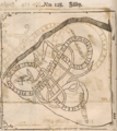 Bautil 128 - U 142.png 2,018 × 2,258; 9.36 MB
-
 Fällbro Runsten U 142.jpg 1,500 × 2,000; 1.67 MB
-
 Runsten Fällbro (U142).jpg 1,296 × 972; 401 KB
-
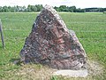 U 142, Fällbro.JPG 1,600 × 1,200; 1.98 MB
-
 U142 Fällbro - KMB - 16000300020613.jpg 768 × 512; 89 KB
-
 Upplands Runinskrifter 142.jpg 3,400 × 4,250; 6.03 MB


