Category:Upplands runinskrifter 1033
Jump to navigation
Jump to search
| Object location | | View all coordinates using: OpenStreetMap |
|---|
 | |||||
| Upload media | |||||
| Instance of |
| ||||
|---|---|---|---|---|---|
| Location | Lena, Uppland, Norunda hundred | ||||
| Heritage designation |
| ||||
 | |||||
|
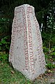
This is a category about an archaeological site or a monument in Sweden, number 10025301620001 in the RAÄ Fornsök database. |
Media in category "Upplands runinskrifter 1033"
The following 8 files are in this category, out of 8 total.
-
 U1033 runes.png 438 × 64; 5 KB
-
 U1033.jpg 689 × 1,000; 259 KB
-
 U1033 Årby - KMB - 16001000202224.jpg 522 × 787; 113 KB
-
 U1033 Årby - KMB - 16001000202244.jpg 522 × 787; 133 KB
-
 U1033 Årby - KMB - 16001000202264.jpg 522 × 787; 115 KB
-
 U1033 Årby - KMB - 16001000202284.jpg 522 × 787; 106 KB
-
 U1033 Årby - KMB - 16001000202304.jpg 522 × 787; 116 KB
-
 U1033 Årby - KMB - 16001000202324.jpg 787 × 522; 109 KB


