Category:Uploads by User:DXR in 2011
Jump to navigation
Jump to search
Media in category "Uploads by User:DXR in 2011"
The following 114 files are in this category, out of 114 total.
-
 7-Eleven Store at 1810 N Cahuenga Blvd, Los Angeles 20110807 1.jpg 4,555 × 2,562; 3.84 MB
-
 Abyss Pool, Yellowstone National Park, South view 20110818 1.jpg 4,928 × 3,080; 7.24 MB
-
 Azure Window, Gozo, South view 20110428 1.jpg 4,622 × 3,061; 5.73 MB
-
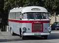 Bedford FBY 053, Gozo 20110428 1.jpg 3,503 × 2,556; 3.02 MB
-
 Bedford FBY 053, Gozo 20110428 2.jpg 3,759 × 3,007; 3.88 MB
-
 Berg's Gold Strike, Main Street, Deadwood, SD 20110821 1.jpg 4,080 × 3,264; 7.64 MB
-
 Bixby Creek Bridge in Fog 20110805 1.jpg 4,894 × 2,753; 4.53 MB
-
 Bridge of US 191 crossing Colorado river near Moab, East view 20110816 2.jpg 4,124 × 2,946; 5.09 MB
-
 Building at Triq Il-Parrocca, Mosta 20110424 1.jpg 3,199 × 4,476; 4.25 MB
-
 Buildings at North Rodeo Drive, Beverly Hills, West view 20110806 1 (cropped).jpg 2,108 × 2,652; 2.56 MB
-
 Buildings at North Rodeo Drive, Beverly Hills, West view 20110806 1.jpg 4,375 × 2,931; 5.01 MB
-
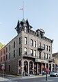 Bullock Hotel, Deadwood SD, North view 20110821 1.jpg 2,719 × 3,817; 3.6 MB
-
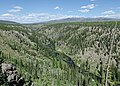
 Canyonlands National Park as seen from Green River Overlook 20110815 1.jpg 4,824 × 3,195; 4.94 MB
-
 Canyonlands National Park, View from Island in the Sky 20110815 1.jpg 3,867 × 2,561; 4.37 MB
-
 Canyonlands National Park, View from Island in the Sky 20110815 2.jpg 4,928 × 3,264; 6.28 MB
-
 Cathedral of St. Mary, Cheyenne, WY, Southwest view 20110823 1.jpg 2,590 × 3,736; 3.45 MB
-
 Cathedral of St. Mary, Cheyenne, WY, West view 20110823 2.jpg 2,542 × 3,876; 4.16 MB
-
 Crossing Deloney and Center, Jackson, WY 20110818 1.jpg 4,655 × 2,984; 5.31 MB
-
 Crossing of 200 South and West Temple, Salt Lake City 20110816 1.jpg 4,928 × 2,697; 4.98 MB
-
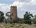 Desert View Tower, GCNP, AZ 20110810 1.jpg 3,968 × 3,066; 4.29 MB
-
 Detail of Lewis River, Yellowstone National Park, looking towards north 20110818 4.jpg 3,109 × 4,353; 7.89 MB
-
 Devils Tower, Southeast remote view 20110821 1.jpg 2,448 × 3,060; 3.2 MB
-
 Devils Tower, Southeast view 20110821 1.jpg 2,707 × 3,990; 5.4 MB
-
 Dodge Coronet Convertible 20110822 1.jpg 4,766 × 3,157; 5.63 MB
-
 Ferry building, San Francisco, South view 20110804 1.jpg 4,928 × 3,264; 6.45 MB
-
 Fresno Street, San Francisco 20110804 1.jpg 3,246 × 4,057; 4.87 MB
-
 Front view of 2006 Dodge Charger in San Francisco 20110804 1.jpg 3,480 × 2,486; 2 MB
-
 Genoa Place, San Francisco 20110804 1.jpg 3,264 × 4,570; 4.83 MB
-
 Grand Canyon of the Yellowstone 20110819 1.jpg 3,188 × 4,813; 7.68 MB
-
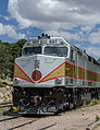
 Grand Canyon Railway EMD F40PH 237, Grand Canyon Village 20110810 1.jpg 3,232 × 2,424; 2.98 MB
-
 Grand Canyon Railway EMD F40PH 237, Grand Canyon Village 20110810 2.jpg 2,796 × 3,626; 3.48 MB
-
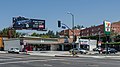
 Grand Central Market, Los Angeles, Interior view 20110807 1.jpg 4,389 × 2,743; 4.73 MB
-
 Grant Ave, San Francisco, looking towards south 20110804 1.jpg 2,614 × 4,158; 3.58 MB
-
 Great Hall, Ellis Island 20110830 1.jpg 3,760 × 3,114; 5.61 MB
-
 Homestake Mine Visitor Center, Lead, SD 20110822 1.jpg 4,860 × 2,734; 4.82 MB
-
 Interstate 40, near Kingman, AZ 20110809 1.jpg 4,928 × 3,264; 6.12 MB
-
 Jackson Lake and Jackson Lake Dam, Grand Teton National Park 20110818 1.jpg 4,663 × 1,726; 3.25 MB
-
 Junction of UT-128 and US-191 near Moab 20110816 1.jpg 3,781 × 2,127; 3.29 MB
-
 Juvenile Brown Pelican in San Francisco 20110804 1.jpg 2,688 × 3,264; 3.71 MB
-
 Landscape in Arches National Park, Utah, Looking east 20110815 2.jpg 4,928 × 3,264; 6.77 MB
-
 Landscape in Arches National Park, Utah, Looking north 20110815 1.jpg 4,928 × 3,264; 6.28 MB
-
 Landscape of Yellowstone National Park near the Lake Lodge 20110818 1.jpg 4,928 × 3,264; 6.97 MB
-
 Lewis River, Yellowstone National Park, looking towards north 20110818 3.jpg 4,168 × 2,977; 6.31 MB
-
 Lincoln Theatre, Cheyenne 20110823 1.jpg 3,986 × 3,189; 4.61 MB
-
 Lower Yellowstone Falls 20110819 1.jpg 2,645 × 3,567; 4.8 MB
-
 Main street looking north, Cedar City, UT 20110813 1.jpg 4,928 × 3,264; 5.45 MB
-
 Mammoth Hot Springs, Yellowstone National Park, View towards Northwest 20110819 1.jpg 4,608 × 3,052; 5.25 MB
-
 Mammoth Hot Springs, Yellowstone National Park, View towards West 20110819 2.jpg 4,928 × 3,264; 6.86 MB
-
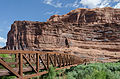 Moab Canyon Pathway, South view 20110816 1.jpg 4,928 × 3,264; 6.76 MB
-
 Mt. Moran and Bivouac Peak, Teton Range, East view 20110818 2.jpg 4,928 × 2,464; 4.88 MB
-
 Nob Hill, San Francisco as seen from Telegraph Hill 20110804 1.jpg 4,122 × 2,301; 3.19 MB
-
 North Caineville Mesa as seen from SR-24, Utah 20110814 1.jpg 4,555 × 3,017; 6.08 MB
-
 North Window, Arches National Park 20110815 1.jpg 4,101 × 2,716; 5.08 MB
-
 Pactola Lake, SD, Southwest view from Pactola Dam 20110822 1.jpg 4,864 × 3,222; 4.98 MB
-
 Pactola Lake, SD, Southwest view from Pactola Dam 20110822 2.jpg 4,928 × 3,264; 6.71 MB
-
 Panoramic view of Los Angeles, from Getty Center 20110807 1.jpg 6,474 × 2,158; 3.9 MB
-
 Perforated Pool, Yellowstone National Park 20110818 1.jpg 4,445 × 3,175; 6.58 MB
-
 Pismo Beach Pier, North view 20110805 1.jpg 3,527 × 1,984; 2.55 MB
-
 Pismo Beach Pier, North view 20110805 2.jpg 4,928 × 1,643; 3.01 MB
-
 Railway tracks near a level crossing with SR-313, Utah 20110815 2.jpg 4,775 × 3,163; 6.1 MB
-
 Roadkill 66 Cafe, Seligman AZ 20110811 1.jpg 4,928 × 3,080; 5.24 MB
-
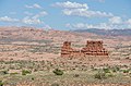
 Rock formation of Capitol Reef National Park near SR-24, Utah 20110814 1.jpg 4,928 × 3,264; 6.78 MB
-
 Rock Formations near Green River Overlook, Canyonlands 20110815 1.jpg 4,927 × 2,861; 5.62 MB
-
 Rocks in Arches National Park as seen from La Sal Mountains Viewpoint 20110815 3.jpg 4,928 × 3,264; 6.28 MB
-
 Rocky Mountains around Mount Ida, Rocky Mountains National Park 20110824 1.jpg 4,928 × 3,080; 5.22 MB
-
 Rocky Mountains around Mount Ida, Rocky Mountains National Park 20110824 2.jpg 4,928 × 3,264; 7.27 MB
-
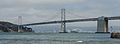 San Francisco–Oakland Bay Bridge, Partial View from Embarcadero 20110804 1.jpg 4,543 × 1,682; 2.36 MB
-
 Seligman Historic Sundries 20110811 1.jpg 4,523 × 3,005; 4.61 MB
-

-
 Sherman Street, Deadwood, SD 20110821 1.jpg 4,264 × 2,824; 4.89 MB
-
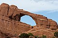 Skyline Arch, Arches National Park 20110815 1.jpg 4,045 × 2,679; 4.27 MB
-
 Snake River near Jackson Lake Dam 20110818 1.jpg 4,902 × 3,247; 5.66 MB
-
 Snake River, Yellowstone National Park, looking towards north 20110818 1.jpg 4,928 × 2,772; 5.86 MB
-
 Snake River, Yellowstone National Park, looking towards southeast 20110818 2.jpg 4,158 × 2,772; 5.47 MB
-
 South view of Rotunda of St. Marija Assunta 20110424 1.jpg 3,452 × 2,818; 3.17 MB
-
 Sunset over the San Luis Obispo Bay, near Pismo Beach 20110805 1.jpg 4,052 × 2,684; 3.85 MB
-
 Teton Range, East view 20110818 1.jpg 4,832 × 2,416; 4.62 MB
-
 The San Remo as seen from Central Park 20110901 1.jpg 3,121 × 4,369; 4.65 MB
-
 Trail Ridge Road, Rocky Mountains National Park 20110824 1.jpg 4,898 × 2,449; 4.68 MB
-
 U.S. Capitol, Washington, D.C., West View 20110826 1.jpg 4,510 × 3,221; 4.77 MB
-
 Union Pacific C44ACCTE 5930 and Southern Pacific 6338 in Wyoming 20110823 1.jpg 4,076 × 2,038; 3.51 MB
-
 UT-24 in Hanksville, Utah 20110814 1.jpg 4,772 × 3,161; 5.8 MB
-
 Utah State Route 12 110814 1.jpg 4,630 × 3,067; 5.46 MB
-
 Utah State Route 24, Near Mile 92 view in Direction North-West 110814 2.jpg 3,199 × 2,125; 3.16 MB
-
 Utah State Route 24, near Mile 92, view in Direction North-West 110814 1.jpg 4,890 × 3,239; 6.36 MB
-
 View from Forest Canyon Overlook, Rocky Mountains National Park 20110824 1.jpg 4,347 × 2,710; 4.34 MB
-
 View of Deadwood, SD and Courthouse 20110821 1.jpg 4,928 × 3,264; 5.9 MB
-
 View of Devils Garden, Arches National Park 20110815 1.jpg 4,928 × 3,264; 6.07 MB
-
 View of Divisavero Street, San Francisco 20110804 1.jpg 4,352 × 3,109; 4.01 MB
-
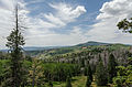 View of Dixie National Forest southwest of UT-14 20110813 1.jpg 4,928 × 3,264; 6.05 MB
-
 View of Dixie National Forest southwest of UT-14 alt 20110813 1.jpg 4,570 × 3,047; 5.36 MB
-
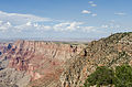 View of Grand Canyon from Navajo Point, GCNP, AZ 20110810 1.jpg 4,864 × 3,222; 6.54 MB
-
 View of I-10 near Desert Center, CA 20110809 1.jpg 4,902 × 3,247; 4.83 MB
-
 View of Madrid and Río Manzanares from Téleferico 20111029 1.jpg 4,928 × 2,772; 6.41 MB
-
 View of Marsalforn and its Bay 20110428 1.jpg 4,877 × 3,048; 5.42 MB
-
 View of Mgarr from Gozo Ferry 20110428 1.jpg 4,085 × 2,298; 3.5 MB
-
 View of Pismo Beach as seen from the pier 20110805 1.jpg 4,855 × 3,216; 4.55 MB
-
 View of Popeye Village, Malta 20110424 1.jpg 4,827 × 3,000; 6.67 MB
-
 View of Rocky Mountains National Park from Many Parks Curve, looking NE 20110824 1.jpg 4,877 × 3,230; 4.86 MB
-
 View of Rocky Mountains National Park from US-36, looking SW 20110824 1.jpg 4,928 × 2,772; 4.39 MB
-
 View of UT-14 in Dixie National Forest 20110813 1.jpg 4,928 × 3,264; 7.88 MB
-
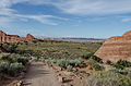
 View of Utah State Route 313 near the intersection with US 191 20110815 1.jpg 4,731 × 3,032; 4.49 MB
-
 View of western seafront of Marsalforn 20110428 2.jpg 4,771 × 2,684; 4.4 MB
-
 West view of Ramla Bay, Gozo 20110428 1.jpg 4,786 × 3,170; 5.49 MB
-
 WYO 24 and Devils Tower, Southeast view 20110821 1 (cropped).jpg 4,144 × 592; 813 KB
-
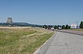 WYO 24 and Devils Tower, Southeast view 20110821 1.jpg 4,928 × 3,264; 5.85 MB
-
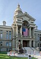 Wyoming State Capitol, Cheyenne, South detail view 20110823 1.jpg 2,418 × 3,494; 3.01 MB
-
 Wyoming Supreme Court Building, Cheyenne, Southwest view 20110823 1.jpg 4,916 × 2,458; 3.88 MB
-
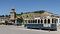
 Wyoming Transportation Museum, Cheyenne, North view 20110823 1.jpg 2,604 × 4,928; 3.96 MB
-
 Xaghra Wikivoyage Banner.jpg 4,786 × 685; 1.56 MB
-

-
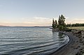
 Yellowstone Lake and trees as seen from West Thumb Geyer Basin Trail 20110818 1.jpg 4,881 × 3,233; 5.67 MB
-
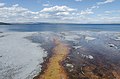 Yellowstone Lake as seen from West Thumb Geyer Basin Trail 20110818 1.jpg 4,830 × 3,199; 5.45 MB
-
 Yellowstone Lake near the Lake Lodge, looking south 20110818 1.jpg 4,674 × 3,096; 4.78 MB


.jpg)


.jpg)