Category:Untergasse 31 (Alsfeld)
Jump to navigation
Jump to search
| Object location | | View all coordinates using: OpenStreetMap |
|---|
This is the category of the Hessian Kulturdenkmal (cultural monument) with the ID 13259 (Wikidata)
|
 | |||||
| Upload media | |||||
| Instance of | |||||
|---|---|---|---|---|---|
| Location | Alsfeld, Vogelsbergkreis, Giessen Government Region, Hesse, Germany | ||||
| Heritage designation | |||||
 | |||||
Media in category "Untergasse 31 (Alsfeld)"
The following 11 files are in this category, out of 11 total.
-
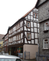 Alsfeld Untergasse 31 13259.png 1,947 × 2,398; 5.78 MB
-
 Alsfeld, Untergasse 31-20160504-001.jpg 4,016 × 6,016; 11.57 MB
-
 Alsfeld, Untergasse 31-20160504-002.jpg 4,016 × 6,016; 12.69 MB
-
 Alsfeld, Untergasse 31-20160504-003.jpg 6,016 × 4,016; 11.11 MB
-
 Alsfeld, Untergasse 31-20160504-004.jpg 4,016 × 6,016; 12.67 MB
-
 Alsfeld, Untergasse 31-20160504-005.jpg 5,749 × 3,838; 11.43 MB
-
 Alsfeld, Untergasse 31-20160504-006.jpg 4,016 × 6,016; 13.15 MB
-
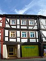 Alsfeld, Untergasse 31.jpg 4,536 × 5,968; 15.67 MB
-
 Stolperstein Fanny Speier, 1, Untergasse 31, Alsfeld, Vogelsbergkreis.jpg 3,456 × 2,592; 5.13 MB
-
 Stolpersteinlage, 1, Untergasse 31, Alsfeld, Vogelsbergkreis.jpg 2,592 × 3,456; 3.64 MB
-
 Untergasse 31, 1, Alsfeld, Vogelsbergkreis.jpg 2,592 × 3,456; 3.26 MB


