Category:Unteres Schulhaus (Hauptstrasse 35, Lüscherz)
Jump to navigation
Jump to search
| Object location | | View all coordinates using: OpenStreetMap |
|---|
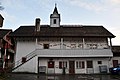
school building in Lüscherz in the canton of Bern, Switzerland  | |||||
| Upload media | |||||
| Instance of | |||||
|---|---|---|---|---|---|
| Part of | |||||
| Location | Lüscherz, Seeland administrative district, Seeland administrative region, Bern, Switzerland | ||||
| Street address |
| ||||
| Heritage designation |
| ||||
| Inception |
| ||||
 | |||||
Media in category "Unteres Schulhaus (Hauptstrasse 35, Lüscherz)"
This category contains only the following file.
-
 2020-Luescherz-Schulhaus.jpg 1,800 × 1,200; 265 KB