Category:Unosu Cliff
Jump to navigation
Jump to search
| Object location | | View all coordinates using: OpenStreetMap |
|---|
cliffs in Tanohata Village, Shimohei District, Iwate Prefecture, Japan  | |||||
| Upload media | |||||
| Instance of | |||||
|---|---|---|---|---|---|
| Named after | |||||
| Located in protected area |
| ||||
| Location | Tanohata, Shimohei district, Iwate Prefecture, Japan | ||||
 | |||||
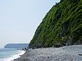
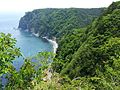
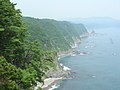
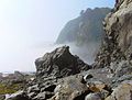
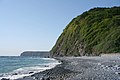
English: Unosu Cliff is the 200 metre-high sea cliff situated at the southern end of the village of Tanohata, Iwate, Japan. Quite a number of Japanese Cormorants and Great Cormorants make nests on its face, which became the name (i.e., Cormorants' nests). Along with Kitayamazaki, it forms the prominent landscape feature of the Rikuchu Coast.
Media in category "Unosu Cliff"
The following 16 files are in this category, out of 16 total.
-
 Unosu 01.jpg 729 × 550; 75 KB
-
 Unos12.jpg 723 × 550; 122 KB
-
 Unos2.jpg 733 × 550; 79 KB
-
 Unos26.jpg 739 × 550; 74 KB
-
 Unos30.jpg 725 × 550; 67 KB
-
 Unos63.jpg 733 × 550; 92 KB
-
 Unos8.jpg 733 × 550; 116 KB
-
 Unosdangai.jpg 715 × 550; 134 KB
-
 Unosu -Observatory deck.jpg 1,024 × 683; 212 KB
-
 Unosu, -beneath the observatory deck.jpg 733 × 550; 123 KB
-
 Unosu-dangai.JPG 2,592 × 1,944; 941 KB
-
 Yamase.jpg 725 × 550; 63 KB
-
 鵜ノ巣断崖Unosu-dangai - panoramio.jpg 2,560 × 1,920; 1.73 MB
-
 鵜ノ巣断崖右側の展望台Unosu-dangai - panoramio.jpg 3,968 × 2,976; 4.33 MB
-
 鵜ノ巣断崖展望台右側Unosu-dangai Tenboudai - panoramio.jpg 3,968 × 2,976; 4.45 MB
-
 鵜ノ巣断崖白池海岸の5月Unosu-dangai Siraike-kaigan - panoramio.jpg 3,456 × 2,304; 737 KB


