Category:United States photographs taken on 2010-07-13
Jump to navigation
Jump to search
Countries of North America: Canada · Costa Rica · Cuba · Guatemala · Mexico · United States of America‡
Other territories: Bermuda · Greenland
‡: partly located in North America
Other territories: Bermuda · Greenland
‡: partly located in North America
| ← | Tuesday 13 July 2010 | → | ||
| ← | July 2010 | → | ||

United States of America photographs taken on 13 July 2010.
Image files should be categorized here automatically using {{taken on}} template. Direct categorisation is also possible, if automatic is impossible.
Media in category "United States photographs taken on 2010-07-13"
The following 75 files are in this category, out of 75 total.
-
 38 SAM 2756 (4842531858).jpg 4,592 × 3,056; 2.12 MB
-

-

-

-
 Alley - panoramio - Steven Wilke.jpg 1,936 × 2,592; 1.19 MB
-
 Amtrak Connersville, IN station.jpg 3,072 × 2,048; 2.84 MB
-
 And the Sky Goes Kaboom (4921797532).jpg 3,456 × 5,184; 17.38 MB
-
 Anubis statue - panoramio.jpg 960 × 1,280; 313 KB
-
 Army Guard commander visits deploying UAS unit (5931830134).jpg 1,200 × 912; 531 KB
-
 Boston vertical 1.JPG 2,271 × 3,648; 1.4 MB
-
 Citrus CR 486 @ US 41 Arrows.JPG 4,000 × 3,000; 2.41 MB
-
 Citrus CR 486 @ US 41 to FL 200.JPG 4,000 × 3,000; 2.42 MB
-
 Clear Creek County, CO, USA - panoramio (10).jpg 1,600 × 1,200; 320 KB
-
 Clear Creek County, CO, USA - panoramio (11).jpg 1,600 × 1,200; 286 KB
-
 Clear Creek County, CO, USA - panoramio (12).jpg 1,600 × 1,200; 313 KB
-
 Clear Creek County, CO, USA - panoramio (13).jpg 1,600 × 1,200; 498 KB
-
 Clear Creek County, CO, USA - panoramio (14).jpg 1,600 × 1,200; 503 KB
-
 Clear Creek County, CO, USA - panoramio (15).jpg 1,600 × 1,200; 367 KB
-
 Dipping lakes July 2010 - panoramio (1).jpg 4,000 × 3,000; 4.1 MB
-
 Dipping lakes July 2010 - panoramio.jpg 4,000 × 3,000; 3.74 MB
-
 Dragonfly molting (5416818298).jpg 3,648 × 2,736; 2.36 MB
-
 Dragonfly molting (5416818644).jpg 3,648 × 2,736; 2.08 MB
-
 Elk Creek bowl - panoramio.jpg 4,000 × 3,000; 3.39 MB
-
 Fernandez Clinton (cropped).jpg 210 × 210; 81 KB
-
 Fernandez Clinton.jpg 1,500 × 998; 1.05 MB
-
 Fighting oil spill DVIDS1097104.jpg 3,872 × 2,592; 1.69 MB
-
 Firefighters fight panic after taking plunge DVIDS302259.jpg 2,912 × 4,368; 4.13 MB
-
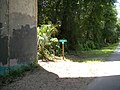
 FLT M04 1.3 mi - Register at junction with Conservation Trail - panoramio.jpg 1,536 × 2,048; 826 KB
-
 FLT M04 2.5 mi - Sign near South Canada Hill Rd - panoramio.jpg 2,048 × 1,536; 836 KB
-

-

-
 FLT M04 4.1 mi - Bridge, Devereaux Crk, showing truss understructure - panoramio.jpg 2,048 × 1,536; 777 KB
-
 FLT M04 4.2 mi - Kiosk near NY 242, backside has pamphlet boxes - panoramio.jpg 2,048 × 1,536; 545 KB
-
 Global Medic 10 DVIDS300123.jpg 4,288 × 2,848; 3.92 MB
-
 Global Medic 10 DVIDS300124.jpg 4,288 × 2,848; 1.84 MB
-
 Global Medic 10 DVIDS300152.jpg 4,288 × 2,848; 3.59 MB
-
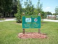
 Inverness Florida Banner.jpg 4,000 × 571; 580 KB
-
 Inverness Trailhead; WST Bathrooms.jpg 4,000 × 3,000; 2.38 MB
-
 Kaleri.png 1,304 × 1,608; 1.41 MB
-
 Kit Carson House Kitchen.JPG 4,320 × 3,240; 5.61 MB
-
 Leonel Fernández en 2010.jpg 186 × 287; 88 KB
-
 Looking back up towards summit - panoramio.jpg 1,600 × 1,200; 579 KB
-
 Marmot - panoramio (1).jpg 1,600 × 1,200; 376 KB
-
 Mountain State MPs Return From Iraq DVIDS301067.jpg 2,400 × 3,332; 4.03 MB
-
 No walking down the center of the tracks... (4791905758).jpg 1,862 × 1,247; 334 KB
-
 Nooksack River, Washington State - panoramio.jpg 2,000 × 3,008; 3.28 MB
-
 NS 7542 (4793476287).jpg 2,631 × 1,684; 699 KB
-
 P071310PS-0302 (4800127990).jpg 4,096 × 2,731; 1.97 MB
-
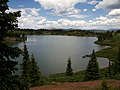 Red lake July 2010 - panoramio.jpg 4,000 × 3,000; 4.37 MB
-
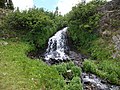 Red Lake waterfall July 2010 - panoramio.jpg 4,000 × 3,000; 4.01 MB
-

-

-

-
 Soyuz TMA-01M crew.jpg 3,838 × 2,559; 962 KB
-
 Swimmers at Devil's Punchbowl near Independence Pass, CO.jpg 725 × 815; 358 KB
-
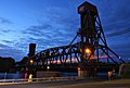 The Builder after sunset (4805753648).jpg 1,024 × 688; 358 KB
-

-
 USMC-100713-M-9234B-001.jpg 4,752 × 3,168; 3.77 MB
-
 USMC-100714-M-3762C-001.jpg 3,528 × 2,286; 2.95 MB
-
 View south above Chama basin July 2010 - panoramio.jpg 4,000 × 3,000; 4.24 MB
-
 Western Tanager in Gila Wilderness (8726014753).jpg 3,648 × 2,736; 2.2 MB
-
 WST Bridge over Henderson Lake.JPG 4,000 × 3,000; 2.83 MB
-
 WST Citrus CR 486 Crosswalk; North Side.jpg 4,000 × 3,000; 2.25 MB
-
 WST Citrus CR 486 Crosswalk; South Side.jpg 4,000 × 3,000; 2.81 MB
-
 WST Hernando Trailhead Park.JPG 4,000 × 3,000; 2.46 MB
-
 WST Hernando Trailhead sign.JPG 4,000 × 3,000; 2.11 MB
-
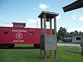 WST Inverness Trailhead; Caboose & Bell.jpg 4,000 × 3,000; 2.34 MB
-
 WST Inverness Trailhead; Citrus Springs to Trilby.jpg 4,000 × 3,000; 2.38 MB
-
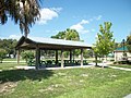 WST Inverness Trailhead; Picnic Shelter.jpg 4,000 × 3,000; 2.39 MB
-
 WST South Detour @ CCR 486.JPG 4,000 × 3,000; 2.78 MB
-
 WST Whispering Pines Park FT Marker.JPG 4,000 × 3,000; 2.8 MB
-
 WST Whispering Pines Park Sign North.JPG 4,000 × 3,000; 2.17 MB
-
 WST Whispering Pines Park Sign South.JPG 4,000 × 3,000; 2.58 MB
-
 WST Whispering Pines Park Steps.JPG 4,000 × 3,000; 2.67 MB
-
 Yellowstone National park gate.jpg 1,200 × 900; 374 KB
.jpg)

.JPG)
.JPG)


.jpg)

.jpg)


.jpg)

.jpg)
.jpg)

.jpg)


.jpg)

.jpg)

.jpg)
.jpg)


.jpg)
.jpg)
.jpg)


.jpg)
._Enterprise_is_making_preparations_for_her_21s.jpg)


.jpg)


.jpg)
.jpg)
.jpg)
.jpg)
.jpg)
.jpg)